IMAGES TAKEN NEAR TO
Higher Croft, MANCHESTER, M30 7AX
Introduction
This page details the photographs taken nearby to Higher Croft, M30 7AX by members of the Geograph project.
The Geograph project started in 2005 with the aim of publishing, organising and preserving representative images for every square kilometre of Great Britain, Ireland and the Isle of Man.

There are currently over 7.5m images from over14,400 individuals and you can help contribute to the project by visiting https://www.geograph.org.uk
Image Map
Images are licensed for reuse under creativecommons.org/licenses/by-sa/2.0
Notes
- Clicking on the map will re-center to the selected point.
- The higher the marker number, the further away the image location is from the centre of the postcode.
Image Listing (73 Images Found)
Images are licensed for reuse under creativecommons.org/licenses/by-sa/2.0
Image
Details
Distance
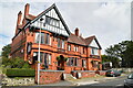
7
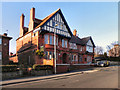
The Rock House
The Rock House public house (formerly Rock Hotel), on Peel Green Road, Barton Upon Irwell.
Image: © David Dixon
Taken: 6 Mar 2011
0.14 miles
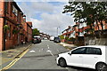
8
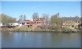
Pub on Peel Green Road, Barton upon Irwell
The name is invisible, from the canal.
Image: © Christine Johnstone
Taken: 13 Apr 2013
0.14 miles