IMAGES TAKEN NEAR TO
Francis Avenue, MANCHESTER, M30 0UF
Introduction
This page details the photographs taken nearby to Francis Avenue, M30 0UF by members of the Geograph project.
The Geograph project started in 2005 with the aim of publishing, organising and preserving representative images for every square kilometre of Great Britain, Ireland and the Isle of Man.

There are currently over 7.5m images from over14,400 individuals and you can help contribute to the project by visiting https://www.geograph.org.uk
Image Map
Images are licensed for reuse under creativecommons.org/licenses/by-sa/2.0
Notes
- Clicking on the map will re-center to the selected point.
- The higher the marker number, the further away the image location is from the centre of the postcode.
Image Listing (54 Images Found)
Images are licensed for reuse under creativecommons.org/licenses/by-sa/2.0
Image
Details
Distance
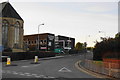
2
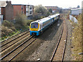
Railway from Liverpool
Looking along the railway from Liverpool and the west. The Arriva train is about to pass under the Old Wellington Road bridge, on its way to Manchester Victoria Station.
Image: © David Dixon
Taken: 12 Apr 2010
0.02 miles
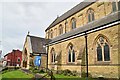
8
Cornerstone Community Church
An independent church based right next to the Anglican church.
Image: © Bill Boaden
Taken: 16 Oct 2010
0.05 miles