IMAGES TAKEN NEAR TO
Oberon Close, MANCHESTER, M30 0PH
Introduction
This page details the photographs taken nearby to Oberon Close, M30 0PH by members of the Geograph project.
The Geograph project started in 2005 with the aim of publishing, organising and preserving representative images for every square kilometre of Great Britain, Ireland and the Isle of Man.

There are currently over 7.5m images from over14,400 individuals and you can help contribute to the project by visiting https://www.geograph.org.uk
Image Map
Images are licensed for reuse under creativecommons.org/licenses/by-sa/2.0
Notes
- Clicking on the map will re-center to the selected point.
- The higher the marker number, the further away the image location is from the centre of the postcode.
Image Listing (50 Images Found)
Images are licensed for reuse under creativecommons.org/licenses/by-sa/2.0
Image
Details
Distance
10
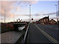
Patricroft Bridge, Eccles
Here the Bridgewater Canal passes under the A57 road, known here as Liverpool Road. The picture was taken looking to the SE. The canal passes through this grid square from the NW to SE.
Image: © Keith Williamson
Taken: 8 Apr 2005
0.13 miles