IMAGES TAKEN NEAR TO
Lower Monton Road, MANCHESTER, M30 0NX
Introduction
This page details the photographs taken nearby to Lower Monton Road, M30 0NX by members of the Geograph project.
The Geograph project started in 2005 with the aim of publishing, organising and preserving representative images for every square kilometre of Great Britain, Ireland and the Isle of Man.

There are currently over 7.5m images from over14,400 individuals and you can help contribute to the project by visiting https://www.geograph.org.uk
Image Map
Images are licensed for reuse under creativecommons.org/licenses/by-sa/2.0
Notes
- Clicking on the map will re-center to the selected point.
- The higher the marker number, the further away the image location is from the centre of the postcode.
Image Listing (148 Images Found)
Images are licensed for reuse under creativecommons.org/licenses/by-sa/2.0
Image
Details
Distance
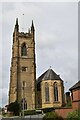
9
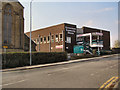
Cornerstone Community Church
The Cornerstone Calvary Chapel on Old Wellington Road, round the corner from Image]; part of which is showing at the left hand side of this photograph.
Image: © David Dixon
Taken: 12 Apr 2010
0.08 miles
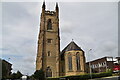
10
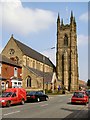
St Andrew's Church
Chadwick Road, Eccles.
Image: © David Dixon
Taken: 12 Apr 2010
0.08 miles