IMAGES TAKEN NEAR TO
Kiel Close, MANCHESTER, M30 0LE
Introduction
This page details the photographs taken nearby to Kiel Close, M30 0LE by members of the Geograph project.
The Geograph project started in 2005 with the aim of publishing, organising and preserving representative images for every square kilometre of Great Britain, Ireland and the Isle of Man.

There are currently over 7.5m images from over14,400 individuals and you can help contribute to the project by visiting https://www.geograph.org.uk
Image Map
Images are licensed for reuse under creativecommons.org/licenses/by-sa/2.0
Notes
- Clicking on the map will re-center to the selected point.
- The higher the marker number, the further away the image location is from the centre of the postcode.
Image Listing (12 Images Found)
Images are licensed for reuse under creativecommons.org/licenses/by-sa/2.0
Image
Details
Distance
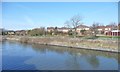
1
Houses on Caledonian Drive
On the north bank of the Manchester Ship Canal.
Image: © Christine Johnstone
Taken: 13 Apr 2013
0.09 miles
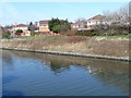
2
Open space off Caledonian Drive
On the north bank of the Manchester Ship Canal.
Image: © Christine Johnstone
Taken: 13 Apr 2013
0.10 miles
3
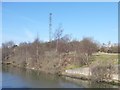
Support for air draft gauge, Manchester Ship Canal
A wire is slung between two towers on opposite banks of the canal. If a ship touches the wire, it is too tall to fit under a nearby bridge.
Image: © Christine Johnstone
Taken: 13 Apr 2013
0.14 miles
4
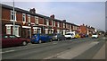
Barton Lane, Eccles
Houses on Barton Lane in Eccles, Greater Manchester, England.
Image: © Steven Haslington
Taken: 30 Mar 2014
0.15 miles
5
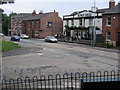
The Kings Head Public House
At the junction of Trafford Rd. with Barton Lane.
Image: © David Newton
Taken: 29 Jun 2009
0.21 miles
6
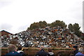
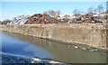
Scrap metal on Irwell Park Wharf
Taken from a Mersey ferry passing by on the Manchester Ship Canal.
Image: © Trevor Harris
Taken: 2 Sep 2012
0.21 miles
7
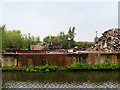
Manchester Ship Canal, Waste Metal Recycling Plant at Irwell Park Wharf
Image: © David Dixon
Taken: 11 May 2016
0.21 miles
9
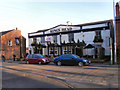
Kings Head
The Kings Head public house on Barton Lane, Patricroft.
Image: © David Dixon
Taken: 6 Mar 2011
0.23 miles
10
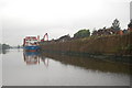
Irwell Park Wharf, western end
On the north bank of the Manchester Ship Canal.
Image: © Christine Johnstone
Taken: 13 Apr 2013
0.24 miles