IMAGES TAKEN NEAR TO
Brindley Close, MANCHESTER, M30 0HZ
Introduction
This page details the photographs taken nearby to Brindley Close, M30 0HZ by members of the Geograph project.
The Geograph project started in 2005 with the aim of publishing, organising and preserving representative images for every square kilometre of Great Britain, Ireland and the Isle of Man.

There are currently over 7.5m images from over14,400 individuals and you can help contribute to the project by visiting https://www.geograph.org.uk
Image Map
Images are licensed for reuse under creativecommons.org/licenses/by-sa/2.0
Notes
- Clicking on the map will re-center to the selected point.
- The higher the marker number, the further away the image location is from the centre of the postcode.
Image Listing (174 Images Found)
Images are licensed for reuse under creativecommons.org/licenses/by-sa/2.0
Image
Details
Distance
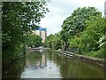
2
Approaching the Barton Aqueduct
The aqueduct carries the Bridgewater Canal first over the B5230 and then the Manchester Ship Canal.
Image: © Gerald England
Taken: 19 Aug 2017
0.02 miles
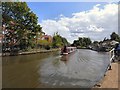
3
Bridgewater Canal
Heading towards the entrance to the Barton Aqueduct.
Image: © David Newton
Taken: 29 Jun 2009
0.03 miles
4
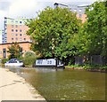
Uncle Monty at Barton
Narrowboat on the Bridgewater Canal.
Image: © Gerald England
Taken: 19 Aug 2017
0.03 miles
5
Crane and stop planks, north of Barton Swing Aqueduct
The Bridgewater Canal is long and lock-free, so has many caches of stop planks in case of a breach.
Image: © Christine Johnstone
Taken: 29 May 2021
0.03 miles
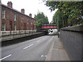
6
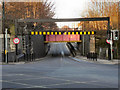
Barton Lane
Not sure if this should be classed as a small canal aqueduct or a very short road tunnel! Barton Lane dips to pass under the Bridgewater Canal at Barton.
Image: © David Dixon
Taken: 6 Mar 2011
0.04 miles
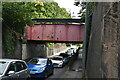
8
Barton Lane Canal Bridge
Looking down Barton Lane to where the Bridgewater Canal crosses over it.
Image: © David Newton
Taken: 29 Jun 2009
0.04 miles
9
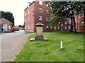
Henry Hall's memorial stone (front view)
This memorial to Henry Hall on Barton Road seems to be the only reminder of Barton Wesleyan Methodist chapel. The chapel was built in 1796 and closed in 1982. http://www.genuki.org.uk/big/eng/LAN/BartononIrwell/BartonRoadWesleyanMethodist
The chapel was demolished in 2001/2 and the site is now occupied by a block of flats, Maranatha Court. The graveyard at the rear was reportedly destroyed and is now a car park. https://www.findagrave.com/cemetery/2445048/Barton-Wesleyan-Methodist-Chapel
Image
Image
Image: © Gerald England
Taken: 19 Aug 2017
0.04 miles
10
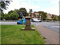
Henry Hall's memorial stone (rear view)
This memorial to Henry Hall on Barton Road seems to be the only reminder of Barton Wesleyan Methodist chapel. The chapel was built in 1796 and closed in 1982. http://www.genuki.org.uk/big/eng/LAN/BartononIrwell/BartonRoadWesleyanMethodist
The chapel was demolished in 2001/2 and the site is now occupied by a block of flats, Maranatha Court. The graveyard at the rear was reportedly destroyed and is now a car park. https://www.findagrave.com/cemetery/2445048/Barton-Wesleyan-Methodist-Chapel
Image
Image
Image: © Gerald England
Taken: 19 Aug 2017
0.04 miles