IMAGES TAKEN NEAR TO
Barton Lane, MANCHESTER, M30 0HG
Introduction
This page details the photographs taken nearby to Barton Lane, M30 0HG by members of the Geograph project.
The Geograph project started in 2005 with the aim of publishing, organising and preserving representative images for every square kilometre of Great Britain, Ireland and the Isle of Man.

There are currently over 7.5m images from over14,400 individuals and you can help contribute to the project by visiting https://www.geograph.org.uk
Image Map
Images are licensed for reuse under creativecommons.org/licenses/by-sa/2.0
Notes
- Clicking on the map will re-center to the selected point.
- The higher the marker number, the further away the image location is from the centre of the postcode.
Image Listing (23 Images Found)
Images are licensed for reuse under creativecommons.org/licenses/by-sa/2.0
Image
Details
Distance
1
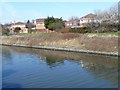
Open space off Caledonian Drive
On the north bank of the Manchester Ship Canal.
Image: © Christine Johnstone
Taken: 13 Apr 2013
0.13 miles
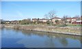
2
Houses on Caledonian Drive
On the north bank of the Manchester Ship Canal.
Image: © Christine Johnstone
Taken: 13 Apr 2013
0.14 miles
3
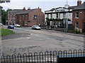
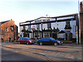
The Kings Head Public House
At the junction of Trafford Rd. with Barton Lane.
Image: © David Newton
Taken: 29 Jun 2009
0.17 miles
4
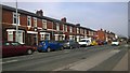
Barton Lane, Eccles
Houses on Barton Lane in Eccles, Greater Manchester, England.
Image: © Steven Haslington
Taken: 30 Mar 2014
0.18 miles
5
Kings Head
The Kings Head public house on Barton Lane, Patricroft.
Image: © David Dixon
Taken: 6 Mar 2011
0.19 miles
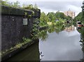
6
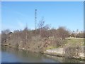
Support for air draft gauge, Manchester Ship Canal
A wire is slung between two towers on opposite banks of the canal. If a ship touches the wire, it is too tall to fit under a nearby bridge.
Image: © Christine Johnstone
Taken: 13 Apr 2013
0.20 miles
7
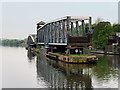
Manchester Ship Canal, Barton Swing Aqueduct
Image: © David Dixon
Taken: 11 May 2016
0.23 miles
8
Manchester Ship Canal from the Barton Swing Aqueduct
A boater's view.
Image: © Christine Johnstone
Taken: 29 May 2021
0.23 miles
9
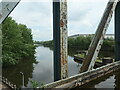
Barton swing aqueduct
Standing on the now closed gate across the canal, with the aqueduct behind me and looking north. Our boat is moored on the right, on the moorings intended for boats approaching the closed aqueduct. But having passed across just before it was swung, the opportunity was too good to miss.
On the abutment wall to the left is a plaque commemorating the opening of the aqueduct in 1895. The engineer was Edward Leader-Williams.
Next picture Image]
Image: © Graham Horn
Taken: 19 Aug 2007
0.24 miles
10
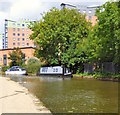
Uncle Monty at Barton
Narrowboat on the Bridgewater Canal.
Image: © Gerald England
Taken: 19 Aug 2017
0.24 miles