IMAGES TAKEN NEAR TO
Vine Street, MANCHESTER, M30 0GF
Introduction
This page details the photographs taken nearby to Vine Street, M30 0GF by members of the Geograph project.
The Geograph project started in 2005 with the aim of publishing, organising and preserving representative images for every square kilometre of Great Britain, Ireland and the Isle of Man.

There are currently over 7.5m images from over14,400 individuals and you can help contribute to the project by visiting https://www.geograph.org.uk
Image Map
Images are licensed for reuse under creativecommons.org/licenses/by-sa/2.0
Notes
- Clicking on the map will re-center to the selected point.
- The higher the marker number, the further away the image location is from the centre of the postcode.
Image Listing (43 Images Found)
Images are licensed for reuse under creativecommons.org/licenses/by-sa/2.0
Image
Details
Distance
1
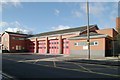
Eccles fire station
Eccles fire station, 288 Liverpool Road, Eccles, Greater Manchester
Image: © Kevin Hale
Taken: 30 Oct 2007
0.09 miles
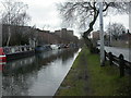
2
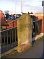
Milestone, Patricroft Bridge, Eccles
This milestone is situated on the B5211 and was retained during reconstruction of the bridge. The text reads "8 miles to Bolton" and "8 miles to Altringham". These days the latter is usually spelt "Altrincham". The B5211 runs alongside the Bridgewater Canal in this square.
Image: © Keith Williamson
Taken: 8 Apr 2005
0.12 miles
3
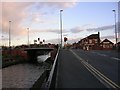
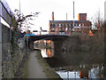
Patricroft Bridge, Eccles
Here the Bridgewater Canal passes under the A57 road, known here as Liverpool Road. The picture was taken looking to the SE. The canal passes through this grid square from the NW to SE.
Image: © Keith Williamson
Taken: 8 Apr 2005
0.12 miles
4
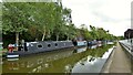
Moorings on the Bridgewater Canal
North of the small basin on the canal at Barton-upon-Irwell
Image: © Kevin Waterhouse
Taken: 9 May 2023
0.13 miles
5
Patricroft, Bridgewater Canal
Looking south along the Bridgewater canal, Britain's first canal that was not river-based. Once important for the Duke of Bridgewater & his coal mines; now for leisure. For further information, see http://www.bridgewatercanal.co.uk/
Image: © Mike Faherty
Taken: 23 Jan 2009
0.14 miles
6
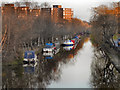
Bridgewater Canal, Patricroft
Looking south along the Bridgewater Canal, from the bridge at Liverpool Road.
Image: © David Dixon
Taken: 6 Mar 2011
0.14 miles
7
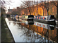
Bridgewater Canal, Barton Business Park
The Bridgewater Canal, running between Barton Road (to the left) and Barton Business Park (the large red brick building to the right).
Image: © David Dixon
Taken: 6 Mar 2011
0.14 miles
8
Bridgewater Canal
Looking roughly north along the Bridgewater Canal towpath. Patricroft Bridge carries the A57 road over the canal in the distance with Bridgewater Mill behind.
Image: © Keith Williamson
Taken: 7 Jan 2007
0.14 miles
9
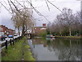
Bridgewater Canal, Liverpool Road Bridge
The bridge carrying Liverpool Road (A57) over the Bridgewater Canal at Patricroft, Eccles. The large building beyond the bridge is Image
Image: © David Dixon
Taken: 6 Mar 2011
0.15 miles
10
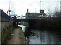
Patricroft, canal towpath
Towpaths were of course used by horses that pulled barges, & their owners; nowadays, they are a useful leisure facility. In front, road bridge carrying the Liverpool Road (A57) across the Bridgewater Canal, and in the distance, Bridgewater Mill Image For details of the canal, see http://www.bridgewatercanal.co.uk/
Image: © Mike Faherty
Taken: 23 Jan 2009
0.15 miles