IMAGES TAKEN NEAR TO
Crawley Avenue, MANCHESTER, M30 0DW
Introduction
This page details the photographs taken nearby to Crawley Avenue, M30 0DW by members of the Geograph project.
The Geograph project started in 2005 with the aim of publishing, organising and preserving representative images for every square kilometre of Great Britain, Ireland and the Isle of Man.

There are currently over 7.5m images from over14,400 individuals and you can help contribute to the project by visiting https://www.geograph.org.uk
Image Map
Images are licensed for reuse under creativecommons.org/licenses/by-sa/2.0
Notes
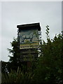
- Clicking on the map will re-center to the selected point.
- The higher the marker number, the further away the image location is from the centre of the postcode.
Image Listing (72 Images Found)
Images are licensed for reuse under creativecommons.org/licenses/by-sa/2.0
Image
Details
Distance
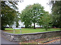
2
The Polygon
An enclave of green, which is partially maintained to preserve habitats.
Image: © Bill Boaden
Taken: 16 May 2016
0.07 miles
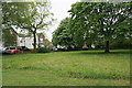
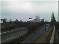
3
The Gilda Brook Roundabout
Where the A576 crosses the M602 at Eccles.
Image: © Bill Boaden
Taken: 16 Oct 2010
0.12 miles
4
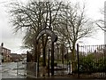
Winton Park gate entrance, Eccles
From Sutherland Street.
Image: © Steve Fareham
Taken: 26 Mar 2009
0.13 miles
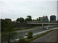
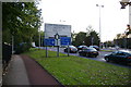
8
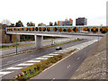
M602 Footbridge, Eccles
This footbridge over the M602 connects Wellington Road with Eccles town centre.
Image: © David Dixon
Taken: 13 Sep 2012
0.14 miles
9
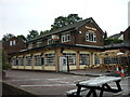
The White Horse public house
On Eccles Old Road.
Image: © Ian S
Taken: 3 Sep 2011
0.15 miles
10
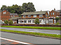
The White Horse, Gilda Brook
The White Horse public house on Eccles Old Road, Gilda Brook
Image: © David Dixon
Taken: 13 Sep 2012
0.15 miles