IMAGES TAKEN NEAR TO
Westerdale Close, MANCHESTER, M29 8SA
Introduction
This page details the photographs taken nearby to Westerdale Close, M29 8SA by members of the Geograph project.
The Geograph project started in 2005 with the aim of publishing, organising and preserving representative images for every square kilometre of Great Britain, Ireland and the Isle of Man.

There are currently over 7.5m images from over14,400 individuals and you can help contribute to the project by visiting https://www.geograph.org.uk
Image Map
Images are licensed for reuse under creativecommons.org/licenses/by-sa/2.0
Notes
- Clicking on the map will re-center to the selected point.
- The higher the marker number, the further away the image location is from the centre of the postcode.
Image Listing (21 Images Found)
Images are licensed for reuse under creativecommons.org/licenses/by-sa/2.0
Image
Details
Distance
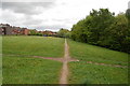
1
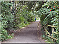
Path from Well Street
The path towards Upton Lane from Well Street, following the course of the old railway line.
Image: © David Dixon
Taken: 28 Aug 2011
0.12 miles
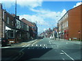
2

Terraced Row - Manchester Road, Tyldesley
Image: © Anthony Parkes
Taken: 8 Jul 2010
0.12 miles
3
Elliott St/Norris Street/Common Lane junction
Image: © Colin Pyle
Taken: 6 Jun 2012
0.12 miles
4

Tyldesley St. Georges Central Primary School
Image: © Margaret Clough
Taken: 12 Jan 2006
0.13 miles
5
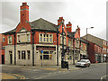
The Mort Arms
The Mort Arms, Elliott Street, Tyldesley.
Image: © David Dixon
Taken: 28 Aug 2011
0.14 miles
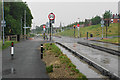
7
Leigh guided busway
Crossing Well Street.
Image: © Gerald England
Taken: 27 Mar 2017
0.14 miles
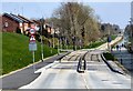
8
Guided busway at Tyldesley
Well Street crosses here. The spire of St George's Church is straight ahead.
Image: © Bill Boaden
Taken: 15 Jun 2020
0.15 miles
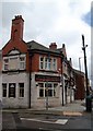
9
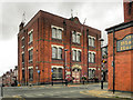
Tyldesley Town Hall
The town hall on Elliott Street. (Now offices for Wigan MBC)
Image: © David Dixon
Taken: 28 Aug 2011
0.15 miles
10
Course of the old railway
This footpath runs along the course of the railway that once linked Manchester with Leigh. It might eventually be the line of a guided busway.
Image: © SMJ
Taken: 8 May 2009
0.15 miles