IMAGES TAKEN NEAR TO
Chester Road, MANCHESTER, M29 8PT
Introduction
This page details the photographs taken nearby to Chester Road, M29 8PT by members of the Geograph project.
The Geograph project started in 2005 with the aim of publishing, organising and preserving representative images for every square kilometre of Great Britain, Ireland and the Isle of Man.

There are currently over 7.5m images from over14,400 individuals and you can help contribute to the project by visiting https://www.geograph.org.uk
Image Map
Images are licensed for reuse under creativecommons.org/licenses/by-sa/2.0
Notes
- Clicking on the map will re-center to the selected point.
- The higher the marker number, the further away the image location is from the centre of the postcode.
Image Listing (21 Images Found)
Images are licensed for reuse under creativecommons.org/licenses/by-sa/2.0
Image
Details
Distance
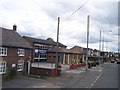
3
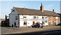
Colliers Arms, Tyldesley
The Colliers Arms is an ancient building on Sale Lane Tyldesley. It is a reminder that Tyldesley once had several collieries. The adjoining cottage is a listed building dating from the late 17th century.
Image: © SMJ
Taken: 12 Feb 2008
0.11 miles
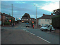
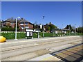
5
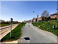
Chester Road
Alongside the Leigh Guided Busway.
Image: © Gerald England
Taken: 20 Apr 2018
0.12 miles
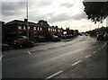
7
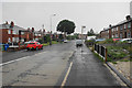
Sale Lane
The A577 heading away from Tyldesley towards Mosley Common.
Image: © Bill Boaden
Taken: 15 Jun 2020
0.12 miles
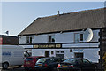
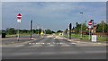
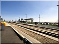
9
Sale Lane bus stop
On the Leigh Guided Busway.
Image: © Gerald England
Taken: 20 Apr 2018
0.16 miles
10
Sale Lane bus stop
On the Leigh Guided Busway.
Image: © Gerald England
Taken: 20 Apr 2018
0.16 miles