IMAGES TAKEN NEAR TO
Mort Lane, MANCHESTER, M29 8PF
Introduction
This page details the photographs taken nearby to Mort Lane, M29 8PF by members of the Geograph project.
The Geograph project started in 2005 with the aim of publishing, organising and preserving representative images for every square kilometre of Great Britain, Ireland and the Isle of Man.

There are currently over 7.5m images from over14,400 individuals and you can help contribute to the project by visiting https://www.geograph.org.uk
Image Map
Images are licensed for reuse under creativecommons.org/licenses/by-sa/2.0
Notes
- Clicking on the map will re-center to the selected point.
- The higher the marker number, the further away the image location is from the centre of the postcode.
Image Listing (14 Images Found)
Images are licensed for reuse under creativecommons.org/licenses/by-sa/2.0
Image
Details
Distance
1
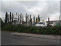
Open Storage Land, Mort Lane, Tyldesley
Image: © Anthony Parkes
Taken: 9 Jun 2010
0.06 miles
2
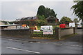
Makants Farm
An active farm though the buildings in this view are derelict.
Image: © Bill Boaden
Taken: 15 Jun 2020
0.06 miles

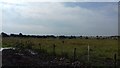
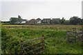
5
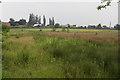
Boggy scrub near Bank House Farm
The buildings show the line of Mort Lane, the A5082. A brook crosses the intervening land.
Image: © Bill Boaden
Taken: 15 Jun 2020
0.13 miles
6
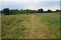
Path to Little Hulton
This is now an established route though it has evolved from the original route of the public footpaths.
Image: © Bill Boaden
Taken: 15 Jun 2020
0.14 miles
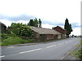
8
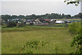
Bank House Farm
As seen from Mort Lane. The farm has several ruined buildings but still houses a large collection of vehicles and also a light aircraft.
Image: © Bill Boaden
Taken: 15 Jun 2020
0.16 miles
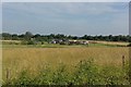
10
The edge of Tyldesley
The buildings are in Highfield Grove, a fairly recent expansion of the housing along Mort Lane. The sombre lighting is due to the thundery rain falling at the time.
Image: © Bill Boaden
Taken: 15 Jun 2020
0.20 miles