IMAGES TAKEN NEAR TO
Upton Lane, MANCHESTER, M29 8NY
Introduction
This page details the photographs taken nearby to Upton Lane, M29 8NY by members of the Geograph project.
The Geograph project started in 2005 with the aim of publishing, organising and preserving representative images for every square kilometre of Great Britain, Ireland and the Isle of Man.

There are currently over 7.5m images from over14,400 individuals and you can help contribute to the project by visiting https://www.geograph.org.uk
Image Map
Images are licensed for reuse under creativecommons.org/licenses/by-sa/2.0
Notes
- Clicking on the map will re-center to the selected point.
- The higher the marker number, the further away the image location is from the centre of the postcode.
Image Listing (7 Images Found)
Images are licensed for reuse under creativecommons.org/licenses/by-sa/2.0
Image
Details
Distance
1
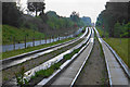
Guided busway at Tyldesley
Looking towards the Upton Lane crossing on a wet day.
Image: © Bill Boaden
Taken: 15 Jun 2020
0.05 miles
2
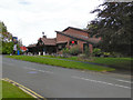
The Gatehouse
Public house on Cherington Drive
Image: © David Dixon
Taken: 28 Aug 2011
0.08 miles
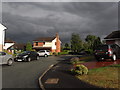
4
Manchester Road (A577)
The A577, Manchester Road, between Tyldesley and Boothstown.
Image: © David Dixon
Taken: 28 Aug 2011
0.23 miles
5
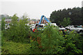
Car breaker's yard by Hough Lane
As seen from the guided busway on a wet day.
Image: © Bill Boaden
Taken: 15 Jun 2020
0.23 miles
6

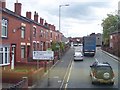
Terraced Row - Manchester Road, Tyldesley
Image: © Anthony Parkes
Taken: 8 Jul 2010
0.23 miles
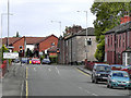
7
Road junction on Manchester Road Tyldesley
Image: © Raymond Knapman
Taken: 24 Jun 2011
0.25 miles