IMAGES TAKEN NEAR TO
Kings Crescent, MANCHESTER, M29 8JY
Introduction
This page details the photographs taken nearby to Kings Crescent, M29 8JY by members of the Geograph project.
The Geograph project started in 2005 with the aim of publishing, organising and preserving representative images for every square kilometre of Great Britain, Ireland and the Isle of Man.

There are currently over 7.5m images from over14,400 individuals and you can help contribute to the project by visiting https://www.geograph.org.uk
Image Map
Images are licensed for reuse under creativecommons.org/licenses/by-sa/2.0
Notes
- Clicking on the map will re-center to the selected point.
- The higher the marker number, the further away the image location is from the centre of the postcode.
Image Listing (6 Images Found)
Images are licensed for reuse under creativecommons.org/licenses/by-sa/2.0
Image
Details
Distance
1
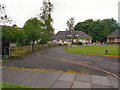
Jubilee Houses, King's Crescent, Tyldesley
Image: © David Dixon
Taken: 2 Jun 2012
0.02 miles
2
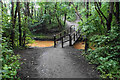
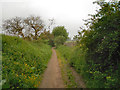
Footbridge over Hindsford Brook
The path follows the line of the former Manchester & Wigan Railway.
Image: © Bill Boaden
Taken: 15 Jun 2020
0.08 miles
3
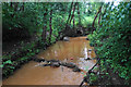
Hindsford Brook
A small brook between Atherton and Tyldesley which eventually feeds Glaze Brook and the Mersey. This is looking upstream from the former Manchester & Wigan Railway.
Image: © Bill Boaden
Taken: 15 Jun 2020
0.08 miles
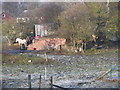
6
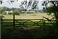
Lodge Farm
It is viewed in a brief break in the foliage which lines the former Manchester & Wigan Railway.
Image: © Bill Boaden
Taken: 15 Jun 2020
0.22 miles