IMAGES TAKEN NEAR TO
Lemon Street, MANCHESTER, M29 8HT
Introduction
This page details the photographs taken nearby to Lemon Street, M29 8HT by members of the Geograph project.
The Geograph project started in 2005 with the aim of publishing, organising and preserving representative images for every square kilometre of Great Britain, Ireland and the Isle of Man.

There are currently over 7.5m images from over14,400 individuals and you can help contribute to the project by visiting https://www.geograph.org.uk
Image Map
Images are licensed for reuse under creativecommons.org/licenses/by-sa/2.0
Notes
- Clicking on the map will re-center to the selected point.
- The higher the marker number, the further away the image location is from the centre of the postcode.
Image Listing (97 Images Found)
Images are licensed for reuse under creativecommons.org/licenses/by-sa/2.0
Image
Details
Distance
1
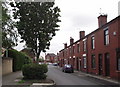
School Street Tyldesley
Partly pedestrianised, with small front gardens laid out, this attempt to modernise and gentrify an old Victorian terraced street has, by and large, been successful.
Image: © Phil and Juliette Platt
Taken: 24 May 2011
0.01 miles
2
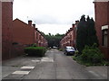
Lemon St Tyldesley
Looking south towards the old railway embankment of the line from Tyldesley to Leigh, now a footpath.
Image: © SMJ
Taken: 15 Sep 2007
0.01 miles
3
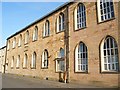
Old St George's School
Generations of Tyldesley children attended the "Church School", one of the few stone buildings in Tyldesley. It has now been converted into apartments.
Image: © SMJ
Taken: 12 Feb 2008
0.02 miles
4
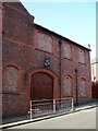
Tyldesley Little Theatre
Home to Tyldesley Amateur Dramatic Society, producing plays for over 80 years. It is situated on Lemon St.
Image: © SMJ
Taken: 12 Feb 2008
0.02 miles
5
St. George's St. Tyldesley
Close to the town centre and the church of the same name.
Image: © Phil and Juliette Platt
Taken: 24 May 2011
0.03 miles
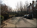
6
Back Lemon Street -Tyldesley
Showing the rear of the Tyldesley Little Theatre
Image: © Dave Green
Taken: 23 Apr 2008
0.04 miles
7
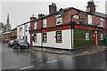
The Railway, Tyldesley
The actual railway used to be further down the hill behind me, where the guided busway now runs. The pub is shut during the coronavirus lockdown.
Image: © Bill Boaden
Taken: 15 Jun 2020
0.04 miles
8
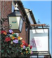
Sign of The Railway
The signage on The Railway Image refers to Mayfair Taverns whom it seems were bought out in 1998 by Enterprise Inns who are now known as the Ei group.
Image: © Gerald England
Taken: 27 Mar 2017
0.04 miles
9
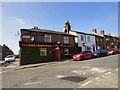
The Railway
Public house on the corner of Wareing Street and St George's Street.
Image
Image: © Gerald England
Taken: 27 Mar 2017
0.05 miles
10
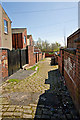
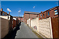
Back Wareing Street - Tyldesley
Showing old cobbled back street
Image: © Dave Green
Taken: 23 Apr 2008
0.05 miles