IMAGES TAKEN NEAR TO
Upper George Street, MANCHESTER, M29 8HQ
Introduction
This page details the photographs taken nearby to Upper George Street, M29 8HQ by members of the Geograph project.
The Geograph project started in 2005 with the aim of publishing, organising and preserving representative images for every square kilometre of Great Britain, Ireland and the Isle of Man.

There are currently over 7.5m images from over14,400 individuals and you can help contribute to the project by visiting https://www.geograph.org.uk
Image Map
Images are licensed for reuse under creativecommons.org/licenses/by-sa/2.0
Notes
- Clicking on the map will re-center to the selected point.
- The higher the marker number, the further away the image location is from the centre of the postcode.
Image Listing (97 Images Found)
Images are licensed for reuse under creativecommons.org/licenses/by-sa/2.0
Image
Details
Distance
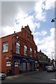
2
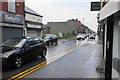
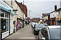
Elliott Street
The main road through the town centre, but the traffic is only one way as part of a gyratory system.
Image: © Bill Boaden
Taken: 15 Jun 2020
0.03 miles
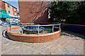
3
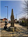
Tyldesley Drinking Fountain
The drinking fountain on Elliott Street is Grade II listed https://historicengland.org.uk/listing/the-list/list-entry/1068444 It dates from 1892 and was donated by John Buckley (1812-1892).
In his will Buckley demonstrated his deep affection for the town by leaving £200 for the construction of "a water drinking fountain for Man, Beasts and Dogs". The fountain was also to serve as a "public lamp pillar" and so was topped with a gas light when in its original Elliott Street position. It was later moved to Tyldesley Park then reinstated in the town centre although on the opposite side of the road to its original site. Bolton News: http://www.theboltonnews.co.uk/news/northwest/9601135.History_book_to_be_reprinted/
Image: © Gerald England
Taken: 27 Mar 2017
0.03 miles
4
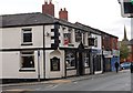
Last Orders
This pub used to be the Welcome Traveller.
Image: © SMJ
Taken: 8 May 2009
0.03 miles
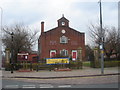
6
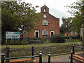
Top Chapel
Top Chapel was Tyldesley's first place of worship. It was built in the Market Square in 1789 for the Countess of Huntingdon's sect which had broken away from the Church of England (http://homepage.ntlworld.com/tjd.davies/Tyldesley%20Top%20Chapel.htm ). It became known as the Top Chapel due to its geographical location. Later another smaller chapel was built at the bottom of the hill and became known as the Bottom Chapel; this chapel no longer exists.
The Chapel, a grade II listed building (http://www.imagesofengland.org.uk/Details/Default.aspx?id=213517- Images of England), became a Pentecostal Chapel in 1970 after being in decline for a number of years and is now The Community Life Church, affiliated to Elim Pentecostal Churches independent (http://www.elim.org.uk/ ).
Image: © David Dixon
Taken: 28 Aug 2011
0.04 miles
7
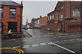
Upper George Street
Tyldesley is built on a ridge, and this view shows the gradient on the southern side of the ridge. The building on the right is the rear and less sightly end of Top Chapel. St George's Church is in the distance.
Image: © Bill Boaden
Taken: 15 Jun 2020
0.05 miles
8
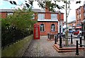
Listed Telephone Box
This telephone box is on The Square in front of "Top Chapel". It is a listed structure.
Image: © SMJ
Taken: 8 May 2009
0.05 miles
9
Tyldesley Miners Hall
Tyldesley Miners Hall was built in 1893. There were several coal mines in Tyldesley. It is now used by a dance school.
Image: © SMJ
Taken: 8 May 2009
0.05 miles
10
Tyldesley Top Chapel
On Elliott Street, Tyldesley.
Image: © Margaret Clough
Taken: 5 Jan 2006
0.05 miles