IMAGES TAKEN NEAR TO
Birch Street, MANCHESTER, M29 8ED
Introduction
This page details the photographs taken nearby to Birch Street, M29 8ED by members of the Geograph project.
The Geograph project started in 2005 with the aim of publishing, organising and preserving representative images for every square kilometre of Great Britain, Ireland and the Isle of Man.

There are currently over 7.5m images from over14,400 individuals and you can help contribute to the project by visiting https://www.geograph.org.uk
Image Map
Images are licensed for reuse under creativecommons.org/licenses/by-sa/2.0
Notes
- Clicking on the map will re-center to the selected point.
- The higher the marker number, the further away the image location is from the centre of the postcode.
Image Listing (79 Images Found)
Images are licensed for reuse under creativecommons.org/licenses/by-sa/2.0
Image
Details
Distance
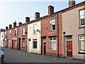
1
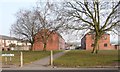
Birch Street, from Ellesmere Street, Tyldesley
Oak, Ash, Birch, Elm and Pine are parallel streets on the north side of Boundary Street.
Image: © Christine Johnstone
Taken: 10 Apr 2013
0.01 miles
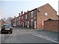
2
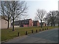
Between Ellesmere and Boundary Streets
Open space in Tyldesley.
Image: © Christine Johnstone
Taken: 10 Apr 2013
0.04 miles
3
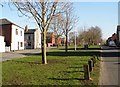
Shakerley Little Common
This grassed area between Boundary St and Ellesmere St was once called Shakerley Little Common, it has never been built on and the name Boundary St suggests the old boundary between Tyldesley and Shakerley
Image: © SMJ
Taken: 13 Feb 2008
0.04 miles
4
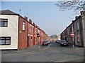
Ash Street, Tyldesley
Oak, Ash, Birch, Elm and Pine are parallel streets on the north side of Boundary Street.
Image: © Christine Johnstone
Taken: 10 Apr 2013
0.04 miles
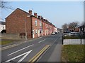
5
Houses on the west side of Henry Street
Immediately north of the eastbound A577 in the centre of Tyldesley.
Image: © Christine Johnstone
Taken: 10 Apr 2013
0.07 miles
6
Johnson Street North, Tyldesley
North of the eastbound A577.
Image: © Christine Johnstone
Taken: 10 Apr 2013
0.08 miles
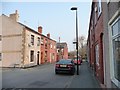
7
Houses on the west side of John Street
Immediately north of the eastbound A577 in Tyldesley.
Image: © Christine Johnstone
Taken: 10 Apr 2013
0.08 miles
9
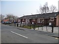
Bungalows on the east side of John Street
Immediately north of the eastbound A577 in Tyldesley.
Image: © Christine Johnstone
Taken: 10 Apr 2013
0.08 miles
10
Blossom Street, Tyldesley
In the middle of the A577 one-way system.
Image: © Christine Johnstone
Taken: 10 Apr 2013
0.12 miles