IMAGES TAKEN NEAR TO
Shuttle Street, MANCHESTER, M29 8BS
Introduction
This page details the photographs taken nearby to Shuttle Street, M29 8BS by members of the Geograph project.
The Geograph project started in 2005 with the aim of publishing, organising and preserving representative images for every square kilometre of Great Britain, Ireland and the Isle of Man.

There are currently over 7.5m images from over14,400 individuals and you can help contribute to the project by visiting https://www.geograph.org.uk
Image Map
Images are licensed for reuse under creativecommons.org/licenses/by-sa/2.0
Notes
- Clicking on the map will re-center to the selected point.
- The higher the marker number, the further away the image location is from the centre of the postcode.
Image Listing (94 Images Found)
Images are licensed for reuse under creativecommons.org/licenses/by-sa/2.0
Image
Details
Distance
1
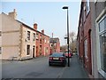
Blossom Street, Tyldesley
In the middle of the A577 one-way system.
Image: © Christine Johnstone
Taken: 10 Apr 2013
0.03 miles
2
Johnson Street North, Tyldesley
North of the eastbound A577.
Image: © Christine Johnstone
Taken: 10 Apr 2013
0.03 miles
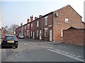
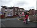
3
Bungalows on the east side of John Street
Immediately north of the eastbound A577 in Tyldesley.
Image: © Christine Johnstone
Taken: 10 Apr 2013
0.03 miles
5
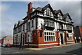
The George
This pub used to be the George and Dragon.
Image: © SMJ
Taken: 8 May 2009
0.05 miles
6
Tyldesley Post Office
On Johnson Street, in the middle of the A577 one way system.
Image: © Christine Johnstone
Taken: 8 Feb 2013
0.05 miles
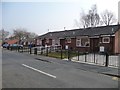
7
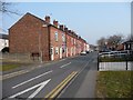
Houses on the west side of John Street
Immediately north of the eastbound A577 in Tyldesley.
Image: © Christine Johnstone
Taken: 10 Apr 2013
0.05 miles
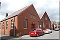
8

Tyldesley Conservative Club
The Conservative club on Stanley Street.
Image: © David Dixon
Taken: 28 Aug 2011
0.06 miles
9
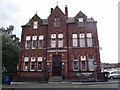
Conservative Club Tyldesley
The building was erected in 1881.
Image: © Phil and Juliette Platt
Taken: 24 May 2011
0.07 miles
10
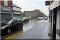
Elliott Street
The main road through the town centre, but the traffic is only one way as part of a gyratory system.
Image: © Bill Boaden
Taken: 15 Jun 2020
0.07 miles