IMAGES TAKEN NEAR TO
Meanley Street, MANCHESTER, M29 8AF
Introduction
This page details the photographs taken nearby to Meanley Street, M29 8AF by members of the Geograph project.
The Geograph project started in 2005 with the aim of publishing, organising and preserving representative images for every square kilometre of Great Britain, Ireland and the Isle of Man.

There are currently over 7.5m images from over14,400 individuals and you can help contribute to the project by visiting https://www.geograph.org.uk
Image Map
Images are licensed for reuse under creativecommons.org/licenses/by-sa/2.0
Notes
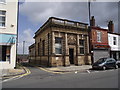
- Clicking on the map will re-center to the selected point.
- The higher the marker number, the further away the image location is from the centre of the postcode.
Image Listing (109 Images Found)
Images are licensed for reuse under creativecommons.org/licenses/by-sa/2.0
Image
Details
Distance
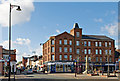
1
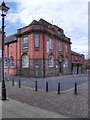
Tyldesley Library
The library on Stanley Street.
Image: © David Dixon
Taken: 28 Aug 2011
0.01 miles
3
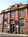
Tyldesley Library
Tyldesley Library is on Stanley Street, it was built with Carnegie money.
Image: © SMJ
Taken: 12 Feb 2008
0.02 miles
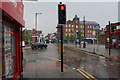
4
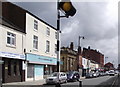
Elliott St. Tyldesley
The main thoroughfare through the town centre, given over mainly to independent shops.
Image: © Phil and Juliette Platt
Taken: 24 May 2011
0.02 miles
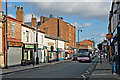
7
Elliott Street
The main street through Tyldesley, but because it is narrow it is one-way as part of a town centre gyratory system. It is seen here at its junction with Astley Street.
Image: © Bill Boaden
Taken: 15 Jun 2020
0.02 miles
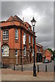
8
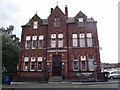
Conservative Club Tyldesley
The building was erected in 1881.
Image: © Phil and Juliette Platt
Taken: 24 May 2011
0.03 miles
9
Stone building in Tyldesley
Clearly, once a bank - but which one I do not know.
Image: © Phil and Juliette Platt
Taken: 24 May 2011
0.03 miles
10
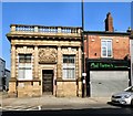
Former Bank on Elliot Street
The single-storey bank, now offices, was built on a corner site c.1900 to the designs of F W Morton. It is constructed in sandstone ashlar with a glazed roof. It has a three-bay front and two-bay left return facing Patchett Street. Its Classical facade has Doric order columns supporting a dentilled cornice and balustraded parapet on a plinth with pedestals. Its central doorway is under a frieze with 'BANK' in raised letters above which is the coat of arms of the Union Bank of Manchester Image At either side are windows in rusticated surrounds with keystones. It is Grade II listed https://historicengland.org.uk/listing/the-list/list-entry/1068459
Image: © Gerald England
Taken: 27 Mar 2017
0.03 miles