IMAGES TAKEN NEAR TO
Rindle Road, MANCHESTER, M29 7LT
Introduction
This page details the photographs taken nearby to Rindle Road, M29 7LT by members of the Geograph project.
The Geograph project started in 2005 with the aim of publishing, organising and preserving representative images for every square kilometre of Great Britain, Ireland and the Isle of Man.

There are currently over 7.5m images from over14,400 individuals and you can help contribute to the project by visiting https://www.geograph.org.uk
Image Map
Images are licensed for reuse under creativecommons.org/licenses/by-sa/2.0
Notes
- Clicking on the map will re-center to the selected point.
- The higher the marker number, the further away the image location is from the centre of the postcode.
Image Listing (27 Images Found)
Images are licensed for reuse under creativecommons.org/licenses/by-sa/2.0
Image
Details
Distance
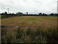
1
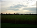
Rindle Farm, Astley Moss
Taken from the entrance to Rindle Farm on Rindle Road, Astley Moss, near Tyldesley, Greater Manchester, I am looking south to the Liverpool to Manchester railway line.
Image: © Carroll Pierce
Taken: 28 Dec 2015
0.02 miles
2
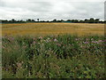
Rindle Farm
Taken on the track passing through Rindle Farm, Astley Moss, near Leigh, Greater Manchester, I am looking south towards the railway line to Liverpool. The ditch right in front of me is lush with the growth of typha (bulrush), Himalayan balsam and what I think is mugwort.
Image: © Carroll Pierce
Taken: 12 Aug 2018
0.06 miles
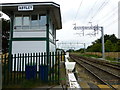
3
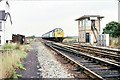
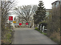
Astley Moss railway crossing
The signal cabin is on view and a post office van is crossing the lines. The gates have to be open and closed manually by road users.
Image: © Raymond Knapman
Taken: 31 Jul 2014
0.08 miles
4
Astley signalbox 1979
A Manchester Victoria to Llandudno train passes over the level crossing at Astley on Chat Moss in August 1979. The houses on the left were originally for the crossing keepers who were effectively marooned in the middle of the Moss.
Image: © Peter Whatley
Taken: Unknown
0.08 miles
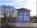
6
Astley crossing control box
The newly installed catenary for the electricfication of the Liverpool Manchester railway on view
Image: © Raymond Knapman
Taken: 31 Jul 2014
0.09 miles
7
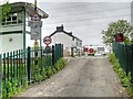
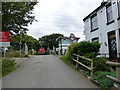
Level Crossing, Control Box and the Former Astley Station House
Image: © David Dixon
Taken: 1 May 2014
0.09 miles
8
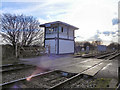
Astley Crossing
The level crossing at Astley Moss. Although Rindle Road crosses the Manchester to Liverpool railway line here, there is no through way as the road on the south side of the crossing is private. The 1940s OS map (http://wtp2.appspot.com/wheresthepath.htm?lat=53.47067744420154&lon=-2.4483298735331593&gz=15&oz=9>=6) shows that there used to be a station here.
Image: © David Dixon
Taken: 19 Mar 2011
0.09 miles
9
Astley Crossing
The level crossing at the end of Rindle Road, at Astley Moss. There is no through way beyond the Manchester to Liverpool railway line as the road on the other side of the crossing is private. There was a station here which closed in 1958 - see http://www.disused-stations.org.uk/a/astley/index.shtml . It is also visible on a 1940s OS map (http://wtp2.appspot.com/wheresthepath.htm?lat=53.47067744420154&lon=-2.4483298735331593&gz=15&oz=9>=6 ).
Image: © David Dixon
Taken: 19 Mar 2011
0.09 miles
10
Liverpool line from Rindle Farm (2)
Taken on the footpath running through Rindle Farm, Astley Moss, I am looking south to the Manchester to Liverpool railway line near Boothstown, Salford, Greater Manchester.
Image: © Carroll Pierce
Taken: 1 Oct 2017
0.10 miles