IMAGES TAKEN NEAR TO
Lower Green Lane, MANCHESTER, M29 7JZ
Introduction
This page details the photographs taken nearby to Lower Green Lane, M29 7JZ by members of the Geograph project.
The Geograph project started in 2005 with the aim of publishing, organising and preserving representative images for every square kilometre of Great Britain, Ireland and the Isle of Man.

There are currently over 7.5m images from over14,400 individuals and you can help contribute to the project by visiting https://www.geograph.org.uk
Image Map
Images are licensed for reuse under creativecommons.org/licenses/by-sa/2.0
Notes
- Clicking on the map will re-center to the selected point.
- The higher the marker number, the further away the image location is from the centre of the postcode.
Image Listing (5 Images Found)
Images are licensed for reuse under creativecommons.org/licenses/by-sa/2.0
Image
Details
Distance
1
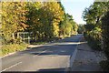
Lower Green Road
The land to the left is a wooded screen around a landfill site.
Image: © Bill Boaden
Taken: 18 Oct 2018
0.05 miles
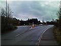
3
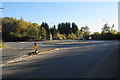
Roundabout near Lower Green
The roads get wider here to accommodate landfill lorries, for which the main access is from the right, avoiding Astley Green.
Image: © Bill Boaden
Taken: 18 Oct 2018
0.15 miles