IMAGES TAKEN NEAR TO
Higher Green Lane, MANCHESTER, M29 7HY
Introduction
This page details the photographs taken nearby to Higher Green Lane, M29 7HY by members of the Geograph project.
The Geograph project started in 2005 with the aim of publishing, organising and preserving representative images for every square kilometre of Great Britain, Ireland and the Isle of Man.

There are currently over 7.5m images from over14,400 individuals and you can help contribute to the project by visiting https://www.geograph.org.uk
Image Map
Images are licensed for reuse under creativecommons.org/licenses/by-sa/2.0
Notes
- Clicking on the map will re-center to the selected point.
- The higher the marker number, the further away the image location is from the centre of the postcode.
Image Listing (98 Images Found)
Images are licensed for reuse under creativecommons.org/licenses/by-sa/2.0
Image
Details
Distance
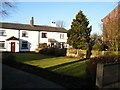
2
Small green in Higher Green
Not the official village green.
Image: © Bill Boaden
Taken: 18 Oct 2018
0.05 miles
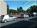
3
Higher Green Lane at Higher Green, Astley
Public Footpath sign seen on the right
Image: © Raymond Knapman
Taken: 31 Jul 2014
0.06 miles
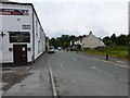
4
Astley Green
Entering Astley Green village via Higher Green lane from The East Lancashire Road.
Image: © David Dixon
Taken: 19 Mar 2011
0.07 miles
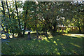
5
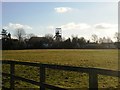
Field at Astley Green
The cottages are at Higher Green and the old colliery headgear is in the far distance.
Image: © SMJ
Taken: 26 Dec 2008
0.08 miles
7
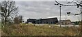
Astley Point
Restaurant and Housing Complex
Image: © Anthony Parkes
Taken: 27 Nov 2020
0.09 miles
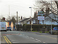
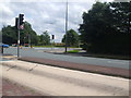
9
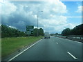
A580 eastbound nears Higher Green junction
Image: © Colin Pyle
Taken: 6 Jun 2012
0.10 miles
10
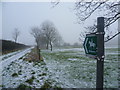
Bridleway between Higher Green & Boothstown
Image: © Anthony Parkes
Taken: 5 Feb 2012
0.11 miles