IMAGES TAKEN NEAR TO
Morleys Lane, MANCHESTER, M29 7EW
Introduction
This page details the photographs taken nearby to Morleys Lane, M29 7EW by members of the Geograph project.
The Geograph project started in 2005 with the aim of publishing, organising and preserving representative images for every square kilometre of Great Britain, Ireland and the Isle of Man.

There are currently over 7.5m images from over14,400 individuals and you can help contribute to the project by visiting https://www.geograph.org.uk
Image Map
Images are licensed for reuse under creativecommons.org/licenses/by-sa/2.0
Notes
- Clicking on the map will re-center to the selected point.
- The higher the marker number, the further away the image location is from the centre of the postcode.
Image Listing (26 Images Found)
Images are licensed for reuse under creativecommons.org/licenses/by-sa/2.0
Image
Details
Distance
1
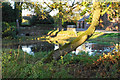
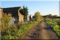
Duck pond by Morley's Hall
This is part of a moat which surrounds the hall to the left.
Image: © Bill Boaden
Taken: 18 Oct 2018
0.02 miles
2
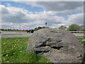
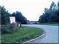
Boulder marking a Junction on the East Lancs Road
Image: © Anthony Parkes
Taken: 9 May 2010
0.04 miles
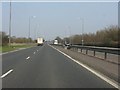
3
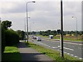
East Lancashire Road
Another view, looking in the Liverpool direction, down the A580, East Lancashire Road in this square to the south of Leigh.
Image: © Keith Williamson
Taken: 19 Sep 2005
0.05 miles
4
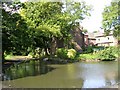
The Moat at Morley's Hall
Morley's Hall is a listed building near Tyldesley to the west of Manchester. On Easter Sunday,1641 Ambrose Barlow, a Roman Catholic priest, was arrested here whilst celebrating a Mass. He was imprisoned and tried at Lancaster and, on 10 September 1641, was hung, drawn and quartered. He was canonised in 1970. His skull is preserved as a relic at nearby Wardley Hall Image
Image: © Keith Williamson
Taken: 19 Sep 2005
0.05 miles
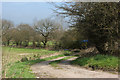
7
A580 near Marsland Green
In the distance the road rises to cross the Bridgewater Canal. The footpath marker on a lamppost on the left is slightly unusual.
Image: © Peter Whatley
Taken: 24 Mar 2011
0.08 miles
8
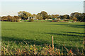
Field near Morley's Hall
Looking towards sewage works on the other side. There is also a gaggle of geese on the far side.
Image: © Bill Boaden
Taken: 18 Oct 2018
0.12 miles
9
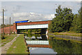
A580 crosses Bridgewater Canal
A580 "East Lancashire Road"
Image: © Dave Green
Taken: 25 Aug 2006
0.13 miles
10
Here's where you come to fill your sand pit
Image: © Ian Greig
Taken: 10 Aug 2010
0.14 miles