IMAGES TAKEN NEAR TO
Longcroft, MANCHESTER, M29 7EN
Introduction
This page details the photographs taken nearby to Longcroft, M29 7EN by members of the Geograph project.
The Geograph project started in 2005 with the aim of publishing, organising and preserving representative images for every square kilometre of Great Britain, Ireland and the Isle of Man.

There are currently over 7.5m images from over14,400 individuals and you can help contribute to the project by visiting https://www.geograph.org.uk
Image Map
Images are licensed for reuse under creativecommons.org/licenses/by-sa/2.0
Notes
- Clicking on the map will re-center to the selected point.
- The higher the marker number, the further away the image location is from the centre of the postcode.
Image Listing (42 Images Found)
Images are licensed for reuse under creativecommons.org/licenses/by-sa/2.0
Image
Details
Distance
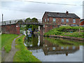
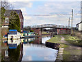
1
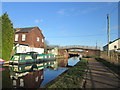
Marsland Green Bridge, Bridgewater Canal
Image: © John Slater
Taken: 20 Jan 2014
0.06 miles
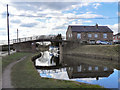
3
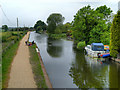
Bridgewater Canal, Marsland Green
Looking towards Leigh, from Marsland Green Bridge.
Image: © David Dixon
Taken: 2 Jun 2012
0.07 miles
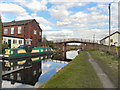
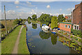
4
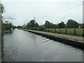
Bridgewater Canal, west of Marsland Green Lane
Looking east from the back of a narrowboat.
Image: © Christine Johnstone
Taken: 23 May 2021
0.07 miles
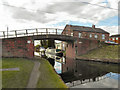
5
Marsland Green Bridge
Marsland Green Bridge on the Bridgewater Canal.
Image: © David Dixon
Taken: 2 Jun 2012
0.07 miles
6
Marsland Green Bridge, Bridgewater Canal
Image: © David Dixon
Taken: 19 Mar 2011
0.07 miles
8
Marsland Green Bridge, Bridgewater Canal
Image: © David Dixon
Taken: 19 Mar 2011
0.07 miles
10
Bridgewater Canal, Marsland Green
View from Marsland Green Bridge
Image: © Dave Green
Taken: 25 Aug 2006
0.07 miles