IMAGES TAKEN NEAR TO
Howbridge Close, MANCHESTER, M28 7XZ
Introduction
This page details the photographs taken nearby to Howbridge Close, M28 7XZ by members of the Geograph project.
The Geograph project started in 2005 with the aim of publishing, organising and preserving representative images for every square kilometre of Great Britain, Ireland and the Isle of Man.

There are currently over 7.5m images from over14,400 individuals and you can help contribute to the project by visiting https://www.geograph.org.uk
Image Map
Images are licensed for reuse under creativecommons.org/licenses/by-sa/2.0
Notes
- Clicking on the map will re-center to the selected point.
- The higher the marker number, the further away the image location is from the centre of the postcode.
Image Listing (18 Images Found)
Images are licensed for reuse under creativecommons.org/licenses/by-sa/2.0
Image
Details
Distance
2
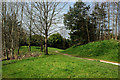
A hidden path
Hidden from the traffic whooshing by on the trunk road
Image: © Ian Greig
Taken: 10 Apr 2010
0.18 miles
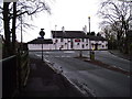
3
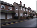
Cottages on Ellenbrook Road
Ellenbrook Road once ran through to Worsley, but now is a cul de sac ending where it meets the busy East Lancs. Road (A580).
Image: © philandju
Taken: 1 Dec 2011
0.18 miles
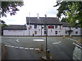
4
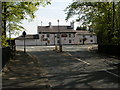
The Red Lion, Ellenbrook
The pub was originally a coaching house. The latest refurbishment of this Tetley's pub was in Spring 2010.
Image: © philandju
Taken: 1 Dec 2011
0.20 miles
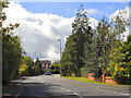
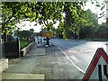
5
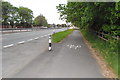
Lay-by on East Lancs Road Ellenbrook
Image: © Anthony Parkes
Taken: 13 May 2010
0.20 miles
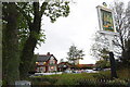
9
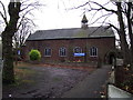
Chapel of St. Mary the Virgin, Ellenbrook
Church of England chapel of ease in the diocese of Manchester.
Image: © philandju
Taken: 1 Dec 2011
0.23 miles