IMAGES TAKEN NEAR TO
Queensway, MANCHESTER, M28 7TZ
Introduction
This page details the photographs taken nearby to Queensway, M28 7TZ by members of the Geograph project.
The Geograph project started in 2005 with the aim of publishing, organising and preserving representative images for every square kilometre of Great Britain, Ireland and the Isle of Man.

There are currently over 7.5m images from over14,400 individuals and you can help contribute to the project by visiting https://www.geograph.org.uk
Image Map
Images are licensed for reuse under creativecommons.org/licenses/by-sa/2.0
Notes
- Clicking on the map will re-center to the selected point.
- The higher the marker number, the further away the image location is from the centre of the postcode.
Image Listing (20 Images Found)
Images are licensed for reuse under creativecommons.org/licenses/by-sa/2.0
Image
Details
Distance
4
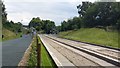
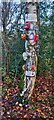
Ellenbrook Loopline
Not usually as slippy as it was today!
Image: © Bradley Michael
Taken: 20 Jan 2023
0.18 miles
5
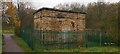
Water Pumping Station
The Thirlmere Aqueduct passes beneath this building
https://hidden-manchester.org.uk/waterways/thirlmere-aqueduct.html
Image: © Anthony Parkes
Taken: 25 Nov 2020
0.19 miles
6
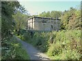
Valve House
For the Thirlmere Aqueduct on the path to Ellenbrook
Image: © Kevin Waterhouse
Taken: 5 Sep 2023
0.19 miles
7

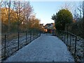
New Children's Play Park
Part of the New Manchester development
Image: © Anthony Parkes
Taken: 25 Nov 2020
0.21 miles
8
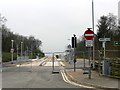
Guided busway construction site
At its junction with Newearth Road in Ellenbrook, this is the end of the guided section of the Leigh-Salford-Manchester Bus Rapid Transit route. This part of the busway, due to open in April 2016, is on the former Tyldesley Loopline railway that closed in 1969.
Image: © Graham Hogg
Taken: 12 Mar 2016
0.21 miles