IMAGES TAKEN NEAR TO
Carlton Close, MANCHESTER, M28 7TX
Introduction
This page details the photographs taken nearby to Carlton Close, M28 7TX by members of the Geograph project.
The Geograph project started in 2005 with the aim of publishing, organising and preserving representative images for every square kilometre of Great Britain, Ireland and the Isle of Man.

There are currently over 7.5m images from over14,400 individuals and you can help contribute to the project by visiting https://www.geograph.org.uk
Image Map
Images are licensed for reuse under creativecommons.org/licenses/by-sa/2.0
Notes
- Clicking on the map will re-center to the selected point.
- The higher the marker number, the further away the image location is from the centre of the postcode.
Image Listing (6 Images Found)
Images are licensed for reuse under creativecommons.org/licenses/by-sa/2.0
Image
Details
Distance
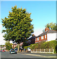
5
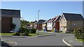
Modern housing estate
A mix of house styles visible in Yarningdale Avenue
Image: © Kevin Waterhouse
Taken: 5 Sep 2023
0.23 miles
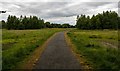
6
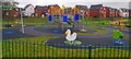
New Children's Play Park
Part of the New Manchester development
Image: © Anthony Parkes
Taken: 25 Nov 2020
0.24 miles