IMAGES TAKEN NEAR TO
Rydal Crescent, MANCHESTER, M28 7JD
Introduction
This page details the photographs taken nearby to Rydal Crescent, M28 7JD by members of the Geograph project.
The Geograph project started in 2005 with the aim of publishing, organising and preserving representative images for every square kilometre of Great Britain, Ireland and the Isle of Man.

There are currently over 7.5m images from over14,400 individuals and you can help contribute to the project by visiting https://www.geograph.org.uk
Image Map (Loading...)


Getting Data...Please wait
Leaflet Map data © OpenStreetMap
Images are licensed for reuse under creativecommons.org/licenses/by-sa/2.0
Notes
- Clicking on the map will re-center to the selected point.
- The higher the marker number, the further away the image location is from the centre of the postcode.
Image Listing (4 Images Found)
Images are licensed for reuse under creativecommons.org/licenses/by-sa/2.0
Image
Details
Distance
1
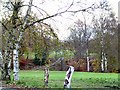
Ellesmere Golf Course
View from the car park by the clubhouse down the track leading to the greens adjacent to the M60 ring road.
Image: © Roger May
Taken: 2 Dec 2005
0.18 miles
2
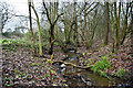
A stream which runs towards the Scout hut and probably feeds Old Warke Dam
Image: © Ian Greig
Taken: 23 Jan 2015
0.19 miles
3
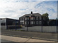
Walkden High School - Specialist Language College
Image: © Anthony Parkes
Taken: 20 Jun 2010
0.22 miles
4
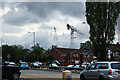
Houses hiding the work on the new Walkden High School
Image: © Ian Greig
Taken: 7 Jul 2010
0.24 miles