IMAGES TAKEN NEAR TO
Lynton Crescent, MANCHESTER, M28 7GB
Introduction
This page details the photographs taken nearby to Lynton Crescent, M28 7GB by members of the Geograph project.
The Geograph project started in 2005 with the aim of publishing, organising and preserving representative images for every square kilometre of Great Britain, Ireland and the Isle of Man.

There are currently over 7.5m images from over14,400 individuals and you can help contribute to the project by visiting https://www.geograph.org.uk
Image Map
Images are licensed for reuse under creativecommons.org/licenses/by-sa/2.0
Notes
- Clicking on the map will re-center to the selected point.
- The higher the marker number, the further away the image location is from the centre of the postcode.
Image Listing (10 Images Found)
Images are licensed for reuse under creativecommons.org/licenses/by-sa/2.0
Image
Details
Distance
2

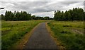
The Worsley to Tyldesley Loopline
Disused railway line has been used to recreate a leisure route
Image: © Anthony Parkes
Taken: 4 Feb 2021
0.14 miles
3
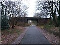
Bridge over Tyldesley Loopline
The footbridge links Broadway to the A580.
Image: © Bradley Michael
Taken: 31 Dec 2022
0.17 miles
4
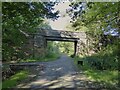
Broadway Bridge
A former road bridge across a former railway. The road, Broadway has been reduced to a path over the bridge and the railway a cycle path, the Tyldesley Loopline.
Image: © Kevin Waterhouse
Taken: 5 Sep 2023
0.17 miles
5

The Tyldesley to Worsley Loopline
Disused railway line has been used to recreate a leisure route
Image: © Anthony Parkes
Taken: 4 Feb 2021
0.20 miles
6
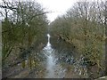
Is this a canal?
No, it's a leisure route - a former railway line - the Tyldesley Loopline, which closed in 1969. This section is now reserved for cyclists and walkers, though fortunately for them the path here is on some higher dry land to the right of the picture.
Image: © Graham Hogg
Taken: 12 Mar 2016
0.20 miles
7
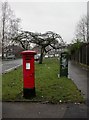
Parr Fold, postbox
At the corner of Walkden Road and Edge Fold Road, GVIR postbox, ID M28 50.
Image: © Mike Faherty
Taken: 13 Jan 2011
0.22 miles
8
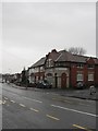
Parr Fold, former Co-op
At the corner of Walkden Road and Shaving Lane; the tiles proclaim it to be "Walkden Co-operative Society Ltd Branch No 5"; now offices.
Image: © Mike Faherty
Taken: 13 Jan 2011
0.22 miles