IMAGES TAKEN NEAR TO
Sharp Street, MANCHESTER, M28 3SW
Introduction
This page details the photographs taken nearby to Sharp Street, M28 3SW by members of the Geograph project.
The Geograph project started in 2005 with the aim of publishing, organising and preserving representative images for every square kilometre of Great Britain, Ireland and the Isle of Man.

There are currently over 7.5m images from over14,400 individuals and you can help contribute to the project by visiting https://www.geograph.org.uk
Image Map
Images are licensed for reuse under creativecommons.org/licenses/by-sa/2.0
Notes
- Clicking on the map will re-center to the selected point.
- The higher the marker number, the further away the image location is from the centre of the postcode.
Image Listing (12 Images Found)
Images are licensed for reuse under creativecommons.org/licenses/by-sa/2.0
Image
Details
Distance
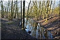
1
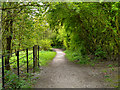
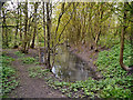
Rotary Way
Footpath from Blackleach Country Park, towards Linneyshaw.
Blackleach Country Park is in what used to be an old industrial area of Walkden, half a mile north of the town centre. Over the last decade or so, the area has been transformed from a derelict site, badly polluted from its former industrial use; in particular, by a chemical factory producing dyes with an adjacent chemical waste heap known locally as 'Stink Bomb Hill' because of the strong sulphurous smell that came off it.
Trees and bushes have now replaced the derelict buildings. Grass and flowers cover what was the toxic waste heap. The rubbish filled reservoir is now a lake with plenty of fish and water birds.
The park was officially designated as a Local Nature Reserve in 2004.
http://www.salford.gov.uk/blackleach.htm Salford City Council
http://www.bbc.co.uk/manchester/content/articles/2008/05/15/friends_blackleach_country_park_feature.shtml BBC Manchester - Park Life
http://en.wikipedia.org/wiki/Blackleach_Country_Park Wikipedia
Image: © David Dixon
Taken: 5 May 2012
0.16 miles
2
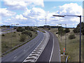
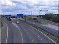
M61 Junction 2
The sliproad onto the M61, from the M60. Viewed from Moss Lane Bridge.
Image: © David Dixon
Taken: 28 Aug 2011
0.20 miles
4
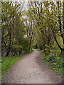
Path in Blackleach Country Park
Blackleach Country Park is in what used to be an old industrial area of Walkden, half a mile north of the town centre. Over the last decade or so, the area has been transformed from a derelict site, badly polluted from its former industrial use; in particular, by a chemical factory producing dyes with an adjacent chemical waste heap known locally as 'Stink Bomb Hill' because of the strong sulphurous smell that came off it.
Trees and bushes have now replaced the derelict buildings. Grass and flowers cover what was the toxic waste heap. The rubbish filled reservoir is now a lake with plenty of fish and water birds.
The park was officially designated as a Local Nature Reserve in 2004.
http://www.salford.gov.uk/blackleach.htm Salford City Council
http://www.bbc.co.uk/manchester/content/articles/2008/05/15/friends_blackleach_country_park_feature.shtml BBC Manchester - Park Life
http://en.wikipedia.org/wiki/Blackleach_Country_Park Wikipedia
Image: © David Dixon
Taken: 5 May 2012
0.21 miles
5
Blackleach Country Park
Blackleach Country Park is in what used to be an old industrial area of Walkden, half a mile north of the town centre. Over the last decade or so, the area has been transformed from a derelict site, badly polluted from its former industrial use; in particular, by a chemical factory producing dyes with an adjacent chemical waste heap known locally as 'Stink Bomb Hill' because of the strong sulphurous smell that came off it.
Trees and bushes have now replaced the derelict buildings. Grass and flowers cover what was the toxic waste heap. The rubbish filled reservoir is now a lake with plenty of fish and water birds.
The park was officially designated as a Local Nature Reserve in 2004.
http://www.salford.gov.uk/blackleach.htm Salford City Council
http://www.bbc.co.uk/manchester/content/articles/2008/05/15/friends_blackleach_country_park_feature.shtml BBC Manchester - Park Life
http://en.wikipedia.org/wiki/Blackleach_Country_Park Wikipedia
Image: © David Dixon
Taken: 5 May 2012
0.22 miles
6
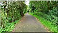
Rotary Way
Path along the old track-bed of the Bridgewater Collieries Railway.
Image: © Peter McDermott
Taken: 26 Sep 2021
0.22 miles
7
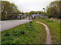
Moss Lane
Moss Lane, approaching the bridge over the M61 motorway.
Image: © David Dixon
Taken: 5 May 2012
0.23 miles
8
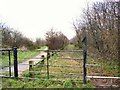
Blackleach Country Walk
This footpath and cycleway through Blackleach Country Park follows the course of the old railway line.
Image: © Roger May
Taken: 14 Dec 2005
0.23 miles
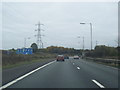
9
M61 Junction 2
The M61, approaching its junction with the M60 (anticlockwise) and westbound A580 (East Lancashire Road)
Image: © David Dixon
Taken: 28 Aug 2011
0.23 miles
10
The outflow from the reservoir at Blackleach Country Park
Image: © Ian Greig
Taken: 6 Feb 2015
0.24 miles