IMAGES TAKEN NEAR TO
Parsonage Road, MANCHESTER, M28 3SD
Introduction
This page details the photographs taken nearby to Parsonage Road, M28 3SD by members of the Geograph project.
The Geograph project started in 2005 with the aim of publishing, organising and preserving representative images for every square kilometre of Great Britain, Ireland and the Isle of Man.

There are currently over 7.5m images from over14,400 individuals and you can help contribute to the project by visiting https://www.geograph.org.uk
Image Map
Images are licensed for reuse under creativecommons.org/licenses/by-sa/2.0
Notes
- Clicking on the map will re-center to the selected point.
- The higher the marker number, the further away the image location is from the centre of the postcode.
Image Listing (18 Images Found)
Images are licensed for reuse under creativecommons.org/licenses/by-sa/2.0
Image
Details
Distance
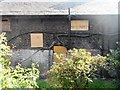
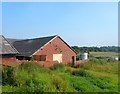
8
Where Burgess Farmhouse once stood
Before demolition: https://m.geograph.org.uk/photo/3547874
Image: © Anthony Parkes
Taken: 25 Nov 2020
0.21 miles
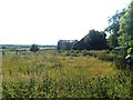
9
The end of Salford's last working farm
Burgess Farm was Salford's last working farm. Planning Permission has been granted to create 350 new homes on the site against the wishes of many local residents.
Image: © Anthony Parkes
Taken: 9 Jul 2013
0.22 miles
10
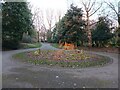
Circle of plants 2 - signs of spring
Same view as Image, with some early February bloom.
Image: © Bradley Michael
Taken: 14 Feb 2023
0.22 miles