IMAGES TAKEN NEAR TO
Albert Avenue, MANCHESTER, M28 3GE
Introduction
This page details the photographs taken nearby to Albert Avenue, M28 3GE by members of the Geograph project.
The Geograph project started in 2005 with the aim of publishing, organising and preserving representative images for every square kilometre of Great Britain, Ireland and the Isle of Man.

There are currently over 7.5m images from over14,400 individuals and you can help contribute to the project by visiting https://www.geograph.org.uk
Image Map
Images are licensed for reuse under creativecommons.org/licenses/by-sa/2.0
Notes
- Clicking on the map will re-center to the selected point.
- The higher the marker number, the further away the image location is from the centre of the postcode.
Image Listing (9 Images Found)
Images are licensed for reuse under creativecommons.org/licenses/by-sa/2.0
Image
Details
Distance
1
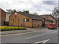
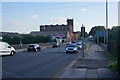
Worsley Road North Methodist Church, Walkden
Image: © David Dixon
Taken: 2 May 2010
0.06 miles
2
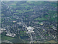
Walkden from the air
The M61 motorway is visible in the lower left corner. Bleckleach Reservoir is visible at the bottom of the photo, the A575 Bolton Road is also prominent.
Viewed from a Manchester bound flight from Prague.
Image: © Thomas Nugent
Taken: 18 Apr 2014
0.07 miles
3
Harcourt Industrial Centre
An area of light industry in north Walkden.
Image: © Keith Williamson
Taken: 27 Jan 2006
0.10 miles
5
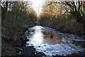
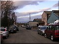
Rotary Way
At this point the path is not only flooded but frozen. Further on it was closed until the end of March "for construction work",
Image: © Ian Greig
Taken: 6 Feb 2015
0.14 miles
7
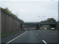
Worsley Road crossing the M61
The motorway bridge is the boundary between Bolton and Salford Metropolitan Boroughs.
Image: © Bill Boaden
Taken: 7 Sep 2015
0.23 miles
8
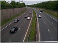
M61 from Farnworth
Viewed from Worsley Road, just on the Bolton side of its border with Salford.
Image: © Bradley Michael
Taken: 2 Jul 2013
0.24 miles
9
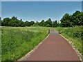
Cycle path following route of former railway
On the former Bridgewater Colliery railway route now known as the Linnyshaw Loopline. The open land is the site of Ashton's Field Colliery.
Image: © Kevin Waterhouse
Taken: 12 Jun 2023
0.25 miles