IMAGES TAKEN NEAR TO
Old Warke Dam, MANCHESTER, M28 2WP
Introduction
This page details the photographs taken nearby to Old Warke Dam, M28 2WP by members of the Geograph project.
The Geograph project started in 2005 with the aim of publishing, organising and preserving representative images for every square kilometre of Great Britain, Ireland and the Isle of Man.

There are currently over 7.5m images from over14,400 individuals and you can help contribute to the project by visiting https://www.geograph.org.uk
Image Map
Images are licensed for reuse under creativecommons.org/licenses/by-sa/2.0
Notes
- Clicking on the map will re-center to the selected point.
- The higher the marker number, the further away the image location is from the centre of the postcode.
Image Listing (19 Images Found)
Images are licensed for reuse under creativecommons.org/licenses/by-sa/2.0
Image
Details
Distance
2
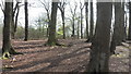
Worsley Woods
Children's activity area in Worsley Woods
Image: © Anthony Parkes
Taken: 27 Mar 2009
0.06 miles
3
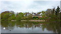
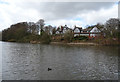
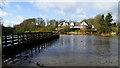
Old Warke Dam
With The Aviary on the opposite bank, an historic property
Image: © Kevin Waterhouse
Taken: 6 Jun 2023
0.08 miles
4
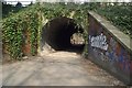
Bridge over Worsley Loop Line
Disused railway, now a footpath.
Image: © philandju
Taken: 9 Apr 2013
0.08 miles
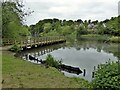
5
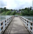
Pier at the Old Warke Dam - Worsley Woods
Image: © Anthony Parkes
Taken: 21 Jun 2015
0.09 miles
8
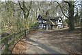
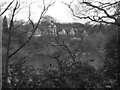
The Aviary, Worsley
The Aviary is seen from the opposite side of Old Warke Dam.
Image: © habiloid
Taken: 25 Mar 2016
0.09 miles
10
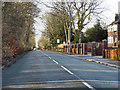
Greenleach Lane, Broadoak
Greenleach Lane, in the Broadoak area of Salford.
Image: © David Dixon
Taken: 24 Feb 2011
0.15 miles