IMAGES TAKEN NEAR TO
Worsley Road, MANCHESTER, M28 2NN
Introduction
This page details the photographs taken nearby to Worsley Road, M28 2NN by members of the Geograph project.
The Geograph project started in 2005 with the aim of publishing, organising and preserving representative images for every square kilometre of Great Britain, Ireland and the Isle of Man.

There are currently over 7.5m images from over14,400 individuals and you can help contribute to the project by visiting https://www.geograph.org.uk
Image Map
Images are licensed for reuse under creativecommons.org/licenses/by-sa/2.0
Notes
- Clicking on the map will re-center to the selected point.
- The higher the marker number, the further away the image location is from the centre of the postcode.
Image Listing (199 Images Found)
Images are licensed for reuse under creativecommons.org/licenses/by-sa/2.0
Image
Details
Distance
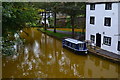
1
Worsley junction
The view towards Worsley Delph, where can be found the old underground mine workings which the canal was built to serve.
Image: © Alan Murray-Rust
Taken: 18 Sep 2009
0.01 miles
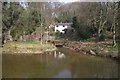
2
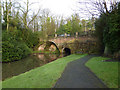
Worsley Road Bridge
Bridge c1760 over the Bridgwater Canal
Image: © Richard Croft
Taken: 24 Feb 2011
0.02 miles
3
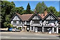
Tung Fong
The restaurant at 2 Worsley Road was founded in 1989.
The premises next door at 4 Worsley Road used to be Owen Knox Estates but having merged with Hunters Estate Agents the building is for sale.
Image: © Gerald England
Taken: 1 Jul 2017
0.02 miles
5
Iron-stained canal water at Worsley Delph
Image: © David Martin
Taken: 15 Sep 2019
0.02 miles
6
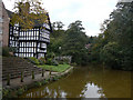
East Basin, Worsley
The Bridgewater canal is by the half-timbered building, Worsley Delph is behind the photographer. This is where coal was brought out of the mines from 1761 onwards and sent off to Salford and Manchester. The site now has excellent interpretation, installed by Salford City Council in 2019 with National Lottery money.
Image: © Christine Johnstone
Taken: 29 May 2021
0.03 miles
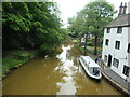
7
Worsley junction
To the right is the branch up into the Delph for the mine workings which were the main reason for the building of the Bridgewater Canal. The line to Leigh continues to the left. The red colour of the water is due to the minerals leaching out of the old mine workings. Straight ahead is Worsley Packet House.
The helmsman of the narrowboat has to make a hard left turn and hope that there is nothing coming the other way through the bridge.
Image: © Alan Murray-Rust
Taken: 18 Sep 2009
0.03 miles
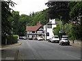
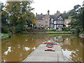
8

The Packet House, Worsley
On the Bridgwater Canal
Image: © Gary Rogers
Taken: 11 Oct 2009
0.03 miles
9
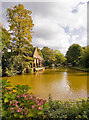
Bridgewater Canal, Worsley
From the Packet House
Image: © Gary Rogers
Taken: 11 Oct 2009
0.03 miles
10
Spur of The Bridgewater Canal
Starting here were 46 miles of underground canals linking the coal mines to the north with The Bridgewater Canal. Coal was transported directly from the coal workings in specially designed M-Boats.
Image: © philandju
Taken: 9 Apr 2013
0.03 miles