IMAGES TAKEN NEAR TO
Hazelfields, MANCHESTER, M28 2LS
Introduction
This page details the photographs taken nearby to Hazelfields, M28 2LS by members of the Geograph project.
The Geograph project started in 2005 with the aim of publishing, organising and preserving representative images for every square kilometre of Great Britain, Ireland and the Isle of Man.

There are currently over 7.5m images from over14,400 individuals and you can help contribute to the project by visiting https://www.geograph.org.uk
Image Map
Images are licensed for reuse under creativecommons.org/licenses/by-sa/2.0
Notes
- Clicking on the map will re-center to the selected point.
- The higher the marker number, the further away the image location is from the centre of the postcode.
Image Listing (10 Images Found)
Images are licensed for reuse under creativecommons.org/licenses/by-sa/2.0
Image
Details
Distance
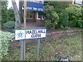
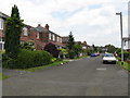
1
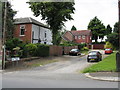
Hazelhall Close, Swinton
A curious cul-de-sac which serves just one, relatively new house.
Image: © Peter Whatley
Taken: 1 Jul 2009
0.04 miles
6
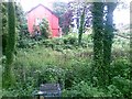
Disused pumping station site, Hazelhurst Road
Image: © Alex McGregor
Taken: 17 Jun 2011
0.16 miles
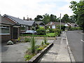
8
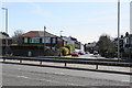
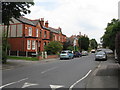
Partington Street
A residential street viewed from the other side of the East Lancs Road.
Image: © Bill Boaden
Taken: 5 Apr 2018
0.18 miles
9
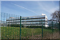
Office block in Wardley Industrial Estate
Part of the BOC Gas & Gear centre.
Image: © Bill Boaden
Taken: 5 Apr 2018
0.24 miles