IMAGES TAKEN NEAR TO
The Spinney, Chatsworth Road, MANCHESTER, M28 2GH
Introduction
This page details the photographs taken nearby to The Spinney, Chatsworth Road, M28 2GH by members of the Geograph project.
The Geograph project started in 2005 with the aim of publishing, organising and preserving representative images for every square kilometre of Great Britain, Ireland and the Isle of Man.

There are currently over 7.5m images from over14,400 individuals and you can help contribute to the project by visiting https://www.geograph.org.uk
Image Map
Images are licensed for reuse under creativecommons.org/licenses/by-sa/2.0
Notes
- Clicking on the map will re-center to the selected point.
- The higher the marker number, the further away the image location is from the centre of the postcode.
Image Listing (6 Images Found)
Images are licensed for reuse under creativecommons.org/licenses/by-sa/2.0
Image
Details
Distance
1
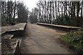
Worsley Railway Station platforms
On the Worsley Loop line, a closed down line now a footpath. The platforms are all that remain of the defunct station.
Image: © philandju
Taken: 9 Apr 2013
0.12 miles
2
Former railway line under Worsley Road
The track is part of the former Monton and Roe Green Loopline.
Image: © Bill Boaden
Taken: 30 Nov 2016
0.16 miles
3
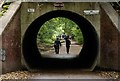
Worsley Road
Path under Worlsey Road.
Image: © Peter McDermott
Taken: 7 Jun 2020
0.19 miles
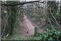
4

Disused railway between Monton & Worsley
Now part of cycle route 55
Image: © Anthony Parkes
Taken: 21 May 2010
0.20 miles
5
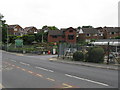
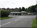
Broadoak Park Garden Centre & Surrounding Houses
Image: © Peter Whatley
Taken: 1 Jul 2009
0.24 miles