IMAGES TAKEN NEAR TO
Sandersons Close, MANCHESTER, M28 2DB

Introduction

This page details the photographs taken nearby to Sandersons Close, M28 2DB by members of the Geograph project.

The Geograph project started in 2005 with the aim of publishing, organising and preserving representative images for every square kilometre of Great Britain, Ireland and the Isle of Man.

There are currently over 7.5m images from over14,400 individuals and you can help contribute to the project by visiting https://www.geograph.org.uk

Image Map


Images are licensed for reuse under creativecommons.org/licenses/by-sa/2.0
Notes
  • Clicking on the map will re-center to the selected point.
  • The higher the marker number, the further away the image location is from the centre of the postcode.

Image Listing (16 Images Found)

Images are licensed for reuse under creativecommons.org/licenses/by-sa/2.0
Image
Details
Distance
1
Gantries - M61 southbound
Image: © Dave Thompson Taken: 31 Mar 2024
0.06 miles
2
M60 Roe Green
Travelling clockwise on the M60, advanced warning of a major junction in one mile at junction 15 when the M61 leaves the M60 (M62 & M66). A critical change of driving direction especially if you're planning to head north on the M61 to the M6 and Scotland as I was.
Image: © Andy Farrington Taken: 20 Jun 2011
0.13 miles
3
Approaching junction 15 on the M60 clockwise
Image: © Ian S Taken: 8 May 2011
0.14 miles
4
Motorway Bridge, Greenleach Lane
The bridge carrying the M60 motorway over Greenleach Lane between Roe Green and Worsley.
Image: © David Dixon Taken: 24 Feb 2011
0.16 miles
5
Sanderson's Sidings
When the railway here was closed in 1969, the trackbed was kept and turned into a footpath "the rail trail" by Salford City Council (http://en.wikipedia.org/wiki/Tyldesley_Loopline )
Image: © David Dixon Taken: 24 Feb 2011
0.19 miles
6
M60
Path under the M60 Motorway.
Image: © Peter McDermott Taken: 7 Jun 2020
0.20 miles
7
Disused Railway Line - Roe Green
Now a national cycle path
Image: © Anthony Parkes Taken: 13 May 2010
0.20 miles
8
Roe Green
A view of the Post Office at Roe Green, Worsley. SD75180156
Image: © Keith Williamson Taken: 5 Sep 2005
0.21 miles
9
Roe Green Independent Methodist Church
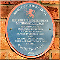
Roe Green Church is situated in the quaint village (of Roe Green!) just off the East Lancashire Road, near Worsley. The church recently celebrated its bi-centenary, having been established in 1808. A plaque on the wall informs us that "The distinguished England cricketers JT Tyldesley (1874), Earnest Tyldesley (1889) and Michael Vaughan (1976) were all baptised in this chapel" (Image]). The Tyldesley brothers are famed in the annals of Lancashire cricket, whilst Mr Vaughan found fame over the border with the white rose county - however we can forgive him as he did captain England's successful team in the 2005 Ashes series, England's first Ashes victory since 1986/7.
Image: © David Dixon Taken: 24 Feb 2011
0.22 miles
10
Plaque On Roe Green Church
The Tyldesley brothers are famous in the annals of Lancashire cricket, whilst Mr Vaughan found his fame across the border with the white rose county - however we can forgive him as he did captain England's successful team in the 2005 Ashes series, England's first Ashes victory since 1986/7.
Image: © David Dixon Taken: 24 Feb 2011
0.22 miles