IMAGES TAKEN NEAR TO
Herevale Grange, MANCHESTER, M28 1ZA
Introduction
This page details the photographs taken nearby to Herevale Grange, M28 1ZA by members of the Geograph project.
The Geograph project started in 2005 with the aim of publishing, organising and preserving representative images for every square kilometre of Great Britain, Ireland and the Isle of Man.

There are currently over 7.5m images from over14,400 individuals and you can help contribute to the project by visiting https://www.geograph.org.uk
Image Map
Images are licensed for reuse under creativecommons.org/licenses/by-sa/2.0
Notes
- Clicking on the map will re-center to the selected point.
- The higher the marker number, the further away the image location is from the centre of the postcode.
Image Listing (24 Images Found)
Images are licensed for reuse under creativecommons.org/licenses/by-sa/2.0
Image
Details
Distance
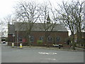
3
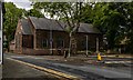
Church of St Mary
Church of St Mary at Ellenbrook.
Image: © Peter McDermott
Taken: 7 Jun 2020
0.13 miles
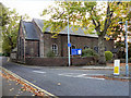
4
Ellenbrook Chapel - St Mary the Virgin
It is thought a chapel has existed on this site since the 13th century.
Image: © Tony Smith
Taken: 23 Mar 2005
0.13 miles
5
Church Of St Mary The Virgin, Ellenbrook
Image: © David Dixon
Taken: 9 Oct 2010
0.14 miles
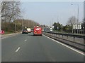
7
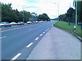
The Ellenbrook Junction on the East Lancs Road
Image: © Ian Greig
Taken: 10 Aug 2010
0.14 miles
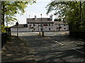
9
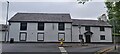
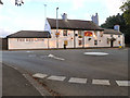
No Longer The Red Lion
Old Public House now converted into a number of dwellings
Image: © Anthony Parkes
Taken: 2 Jul 2021
0.15 miles