IMAGES TAKEN NEAR TO
Verdant Green Close, MANCHESTER, M28 1PN
Introduction
This page details the photographs taken nearby to Verdant Green Close, M28 1PN by members of the Geograph project.
The Geograph project started in 2005 with the aim of publishing, organising and preserving representative images for every square kilometre of Great Britain, Ireland and the Isle of Man.

There are currently over 7.5m images from over14,400 individuals and you can help contribute to the project by visiting https://www.geograph.org.uk
Image Map
Images are licensed for reuse under creativecommons.org/licenses/by-sa/2.0
Notes
- Clicking on the map will re-center to the selected point.
- The higher the marker number, the further away the image location is from the centre of the postcode.
Image Listing (5 Images Found)
Images are licensed for reuse under creativecommons.org/licenses/by-sa/2.0
Image
Details
Distance
3
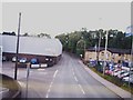
Entrance to Worsley Business Park off Mosley Common Road
Image: © Raymond Knapman
Taken: 24 Jun 2011
0.22 miles
5
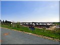
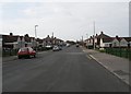
Housing development at Parr Brow
A Redrow development off Mossley Common Road.
Image: © Gerald England
Taken: 20 Apr 2018
0.24 miles