IMAGES TAKEN NEAR TO
Fir Tree Avenue, MANCHESTER, M28 1LP
Introduction
This page details the photographs taken nearby to Fir Tree Avenue, M28 1LP by members of the Geograph project.
The Geograph project started in 2005 with the aim of publishing, organising and preserving representative images for every square kilometre of Great Britain, Ireland and the Isle of Man.

There are currently over 7.5m images from over14,400 individuals and you can help contribute to the project by visiting https://www.geograph.org.uk
Image Map
Images are licensed for reuse under creativecommons.org/licenses/by-sa/2.0
Notes
- Clicking on the map will re-center to the selected point.
- The higher the marker number, the further away the image location is from the centre of the postcode.
Image Listing (55 Images Found)
Images are licensed for reuse under creativecommons.org/licenses/by-sa/2.0
Image
Details
Distance
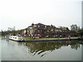
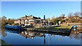
2
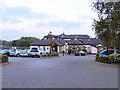
The Moorings
Restaurant/pub at Boothstown Marina
Image: © David Dixon
Taken: 9 Oct 2010
0.09 miles
4
Bridgewater Canal, The Moorings
Pub/restaurant at Bridgewater Marina.
Image: © David Dixon
Taken: 8 Mar 2011
0.10 miles
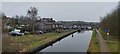
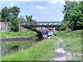
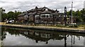
5
The Moorings Pub, Boothstown, Worsley
Quayside Close, Boothstown, Worsley, MANCHESTER M28 1YB on The Bridgewater Canal, Leigh Branch
Image: © canalandriversidepubs co uk
Taken: 9 Apr 2010
0.10 miles
7
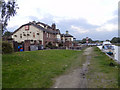
Bridgewater Canal, The Moorings
Restaurant/pub at Boothstown Marina
Image: © David Dixon
Taken: 9 Oct 2010
0.10 miles
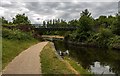
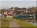
10
The Moorings
Large public house alongside the Bridgewater Canal.
Image: © Peter McDermott
Taken: 7 Jun 2020
0.10 miles