IMAGES TAKEN NEAR TO
Leigh Road, MANCHESTER, M28 1LL
Introduction
This page details the photographs taken nearby to Leigh Road, M28 1LL by members of the Geograph project.
The Geograph project started in 2005 with the aim of publishing, organising and preserving representative images for every square kilometre of Great Britain, Ireland and the Isle of Man.

There are currently over 7.5m images from over14,400 individuals and you can help contribute to the project by visiting https://www.geograph.org.uk
Image Map
Images are licensed for reuse under creativecommons.org/licenses/by-sa/2.0
Notes
- Clicking on the map will re-center to the selected point.
- The higher the marker number, the further away the image location is from the centre of the postcode.
Image Listing (16 Images Found)
Images are licensed for reuse under creativecommons.org/licenses/by-sa/2.0
Image
Details
Distance
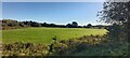
1
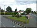
Ellenbrook Road joins Leigh Road at Boothstown
Image: © Raymond Knapman
Taken: 5 Aug 2014
0.08 miles
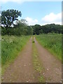
2
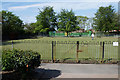
Boothsbank Park
A small park in Boothstown hosting a bowling club.
Image: © Bill Boaden
Taken: 15 May 2018
0.08 miles
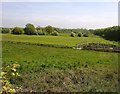
4
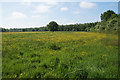
Buttercup field at Boothstown
A fallow area between Boothstown and the Bridgewater Canal.
Image: © Bill Boaden
Taken: 15 May 2018
0.19 miles
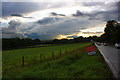
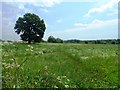
5
Playing Fields near Boothstown Marina
Image: © Anthony Parkes
Taken: 15 Oct 2023
0.20 miles
9
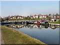
Bridgewater Marina, Boothstown
The Bridgewater Marina, on the Bridgewater Canal, at Boothstown. The houses of Quayside Close are in the background.
Image: © David Dixon
Taken: 8 Mar 2011
0.24 miles
10
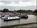
Bridgewater Marina, Boothstown
The Bridgewater Marina (aka Boothstown Marina) on the Bridgewater Canal.
Image: © David Dixon
Taken: 9 Oct 2010
0.24 miles