IMAGES TAKEN NEAR TO
Vicars Hall Lane, MANCHESTER, M28 1JF
Introduction
This page details the photographs taken nearby to Vicars Hall Lane, M28 1JF by members of the Geograph project.
The Geograph project started in 2005 with the aim of publishing, organising and preserving representative images for every square kilometre of Great Britain, Ireland and the Isle of Man.

There are currently over 7.5m images from over14,400 individuals and you can help contribute to the project by visiting https://www.geograph.org.uk
Image Map
Images are licensed for reuse under creativecommons.org/licenses/by-sa/2.0
Notes
- Clicking on the map will re-center to the selected point.
- The higher the marker number, the further away the image location is from the centre of the postcode.
Image Listing (29 Images Found)
Images are licensed for reuse under creativecommons.org/licenses/by-sa/2.0
Image
Details
Distance
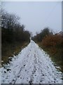
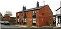
1
Communal Green - Vicars Hall Lane, Boothstown
Image: © Anthony Parkes
Taken: 5 Feb 2012
0.10 miles
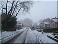
2
Coal & Cotton
The Greyhound Public House has undergone a recent reinvention and change of name
Image: © Anthony Parkes
Taken: 6 Nov 2019
0.13 miles
3
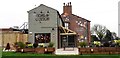
Coal & Cotton - Boothstown
The Greyhound Public House has undergone a recent reinvention and change of name
Image: © Anthony Parkes
Taken: 6 Nov 2019
0.13 miles
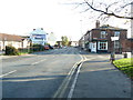
4
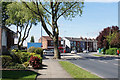
Simpson Road
Near the centre of Boothstown. This acts like a short bypass for Leigh Road which rejoins from the left.
Image: © Bill Boaden
Taken: 15 May 2018
0.14 miles
6
Peacock Butterfly resting in the sun
Image: © Anthony Parkes
Taken: 20 Apr 2022
0.15 miles