IMAGES TAKEN NEAR TO
Moss House Lane, MANCHESTER, M28 1JB
Introduction
This page details the photographs taken nearby to Moss House Lane, M28 1JB by members of the Geograph project.
The Geograph project started in 2005 with the aim of publishing, organising and preserving representative images for every square kilometre of Great Britain, Ireland and the Isle of Man.

There are currently over 7.5m images from over14,400 individuals and you can help contribute to the project by visiting https://www.geograph.org.uk
Image Map
Images are licensed for reuse under creativecommons.org/licenses/by-sa/2.0
Notes
- Clicking on the map will re-center to the selected point.
- The higher the marker number, the further away the image location is from the centre of the postcode.
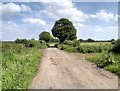
Image Listing (35 Images Found)
Images are licensed for reuse under creativecommons.org/licenses/by-sa/2.0
Image
Details
Distance
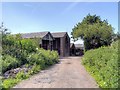
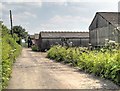
3
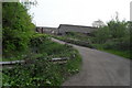
Farm Buildings near Bridgewater Canal
Image: © Anthony Parkes
Taken: 20 May 2010
0.05 miles
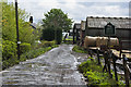
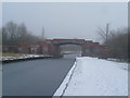
7

Burned out moped on the Bridgewater Canal
Image: © Anthony Parkes
Taken: 10 Oct 2020
0.17 miles
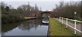
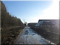
10
![Boothstown Bridge [no 55], from the west](https://s1.geograph.org.uk/geophotos/06/88/85/6888525_f654db1e_120x120.jpg)
Boothstown Bridge [no 55], from the west
Carrying Moss House Lane over the Bridgewater Canal.
Image: © Christine Johnstone
Taken: 23 May 2021
0.17 miles