IMAGES TAKEN NEAR TO
Chaddock Lane, MANCHESTER, M28 1DU
Introduction
This page details the photographs taken nearby to Chaddock Lane, M28 1DU by members of the Geograph project.
The Geograph project started in 2005 with the aim of publishing, organising and preserving representative images for every square kilometre of Great Britain, Ireland and the Isle of Man.

There are currently over 7.5m images from over14,400 individuals and you can help contribute to the project by visiting https://www.geograph.org.uk
Image Map
Images are licensed for reuse under creativecommons.org/licenses/by-sa/2.0
Notes
- Clicking on the map will re-center to the selected point.
- The higher the marker number, the further away the image location is from the centre of the postcode.
Image Listing (13 Images Found)
Images are licensed for reuse under creativecommons.org/licenses/by-sa/2.0
Image
Details
Distance
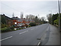
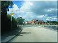
1
Road junction
Of Wallwork Road and Chaddock Lane
Image: © Alexander P Kapp
Taken: 16 Dec 2009
0.01 miles
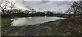
3
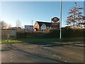
Applewood Farm
A restaurant in Tyldesley near the A580 selling pub grub and a carvery option.
Image: © Bradley Michael
Taken: 20 Jan 2023
0.08 miles
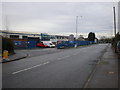
5
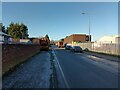
Kennedy Road, Tyldesley
This road is only used for industrial purposes.
Image: © Bradley Michael
Taken: 20 Jan 2023
0.10 miles
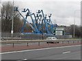
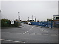
8
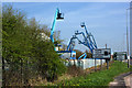
A Martian invasion...
...or cherry pickers?
Image: © Ian Greig
Taken: 10 Apr 2010
0.22 miles
9
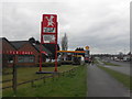
Little Chef & Petrol Station
East Lancs Road, Astley
Image: © Anthony Parkes
Taken: 2 Apr 2010
0.22 miles