IMAGES TAKEN NEAR TO
Hilton Lane, MANCHESTER, M28 0TD
Introduction
This page details the photographs taken nearby to Hilton Lane, M28 0TD by members of the Geograph project.
The Geograph project started in 2005 with the aim of publishing, organising and preserving representative images for every square kilometre of Great Britain, Ireland and the Isle of Man.

There are currently over 7.5m images from over14,400 individuals and you can help contribute to the project by visiting https://www.geograph.org.uk
Image Map
Images are licensed for reuse under creativecommons.org/licenses/by-sa/2.0
Notes
- Clicking on the map will re-center to the selected point.
- The higher the marker number, the further away the image location is from the centre of the postcode.
Image Listing (15 Images Found)
Images are licensed for reuse under creativecommons.org/licenses/by-sa/2.0
Image
Details
Distance
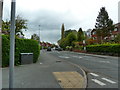
1

1980s Social Comment Regarding Linda Lusardi
Graffiti from the 1980s regarding a glamour model of the time:
https://en.wikipedia.org/wiki/Linda_Lusardi
Image: © Anthony Parkes
Taken: 1 Dec 2020
0.08 miles
2

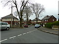
More New Housing
The next phase of the New Manchester Development on what was St George's School Playing Fields.
Image: © Anthony Parkes
Taken: 25 Nov 2020
0.09 miles
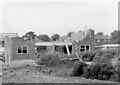
3
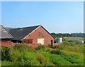
The end of Salford's last working farm
Burgess Farm was Salford's last working farm. Planning Permission has been granted to create 350 new homes on the site against the wishes of many local residents.
Image: © Anthony Parkes
Taken: 9 Jul 2013
0.12 miles
4

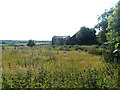
Where Burgess Farmhouse once stood
Before demolition: https://m.geograph.org.uk/photo/3547874
Image: © Anthony Parkes
Taken: 25 Nov 2020
0.12 miles
8
19 & 17 Kent Close under construction 1968
Image: © Michael Frank Parkes
Taken: 21 Sep 1968
0.16 miles
9

New Madams Wood
About 10 years ago this area consisted of watterlogged council sports fields - it has now been transformed in to an oasis of mixed woodland and marsh.
Image: © Anthony Parkes
Taken: 23 Jun 2013
0.19 miles