IMAGES TAKEN NEAR TO
South Grove, MANCHESTER, M28 0SA
Introduction
This page details the photographs taken nearby to South Grove, M28 0SA by members of the Geograph project.
The Geograph project started in 2005 with the aim of publishing, organising and preserving representative images for every square kilometre of Great Britain, Ireland and the Isle of Man.

There are currently over 7.5m images from over14,400 individuals and you can help contribute to the project by visiting https://www.geograph.org.uk
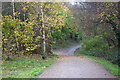
Image Map
Images are licensed for reuse under creativecommons.org/licenses/by-sa/2.0
Notes
- Clicking on the map will re-center to the selected point.
- The higher the marker number, the further away the image location is from the centre of the postcode.
Image Listing (7 Images Found)
Images are licensed for reuse under creativecommons.org/licenses/by-sa/2.0
Image
Details
Distance
1
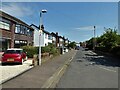
West Avenue
View from the junction with Brougham Street
Image: © Kevin Waterhouse
Taken: 12 Jun 2023
0.07 miles
4

Tesco car park and store, Walkden
Opened fairly recently, the store is alongside the Ellesmere shopping centre.
Image: © philandju
Taken: 1 Feb 2012
0.21 miles
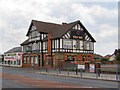
5
Walkden Methodist Church
Manchester Road East.
Image: © David Dixon
Taken: 23 May 2010
0.22 miles
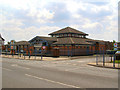
7
A6 Manchester Road at Walkden Methodist Church
Image: © Colin Pyle
Taken: 3 Oct 2015
0.24 miles