IMAGES TAKEN NEAR TO
Hulton Avenue, MANCHESTER, M28 0HH
Introduction
This page details the photographs taken nearby to Hulton Avenue, M28 0HH by members of the Geograph project.
The Geograph project started in 2005 with the aim of publishing, organising and preserving representative images for every square kilometre of Great Britain, Ireland and the Isle of Man.

There are currently over 7.5m images from over14,400 individuals and you can help contribute to the project by visiting https://www.geograph.org.uk
Image Map (Loading...)


Getting Data...Please wait
Leaflet Map data © OpenStreetMap
Images are licensed for reuse under creativecommons.org/licenses/by-sa/2.0
Notes
- Clicking on the map will re-center to the selected point.
- The higher the marker number, the further away the image location is from the centre of the postcode.
Image Listing (13 Images Found)
Images are licensed for reuse under creativecommons.org/licenses/by-sa/2.0
Image
Details
Distance
1
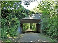
Hilton Lane Bridge
Across a former railway now the Roe Green Loopline cycle route
Image: © Kevin Waterhouse
Taken: 12 Jun 2023
0.09 miles

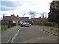
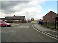
4

Hilton Lane Primary School, Madams Wood Avenue
Image: © Anthony Parkes
Taken: 9 Jun 2010
0.11 miles

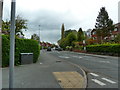
9
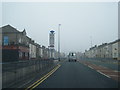
A6 Manchester Road East at Little Hulton boundary
Image: © Colin Pyle
Taken: 3 Oct 2015
0.22 miles
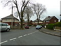
10
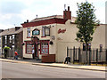
The Shamrock
241 Manchester Road East, Little Hulton.
Image: © David Dixon
Taken: 23 May 2010
0.22 miles