IMAGES TAKEN NEAR TO
Moss Bank Road, MANCHESTER, M27 9XB
Introduction
This page details the photographs taken nearby to Moss Bank Road, M27 9XB by members of the Geograph project.
The Geograph project started in 2005 with the aim of publishing, organising and preserving representative images for every square kilometre of Great Britain, Ireland and the Isle of Man.

There are currently over 7.5m images from over14,400 individuals and you can help contribute to the project by visiting https://www.geograph.org.uk
Image Map
Images are licensed for reuse under creativecommons.org/licenses/by-sa/2.0
Notes
- Clicking on the map will re-center to the selected point.
- The higher the marker number, the further away the image location is from the centre of the postcode.
Image Listing (7 Images Found)
Images are licensed for reuse under creativecommons.org/licenses/by-sa/2.0
Image
Details
Distance
1
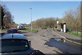
Bus stop and turning circle on Mossfield Road
The top end of the Newtown estate.
Image: © Bill Boaden
Taken: 5 Apr 2018
0.17 miles
2
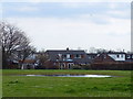
Field at Rear of Sindsley Road, Wardley
Image: © Gary Rogers
Taken: 31 Mar 2019
0.18 miles
3
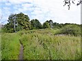
Path approaching M60 motorway footbridge
In the foliage is the bridge allowing access to Clifton from Wardley
Image: © Kevin Waterhouse
Taken: 4 Sep 2023
0.19 miles
4
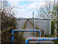
Footbridge over the M60 North of Wardley
Image: © Gary Rogers
Taken: 31 Mar 2019
0.21 miles
5
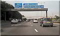
M60 Motorway, Approaching J15
The anticlockwise carriageway of the M60, as it approaches Junction 15, the exit for the north, via the M61.
Image: © David Dixon
Taken: 4 Sep 2010
0.21 miles
6

M60 Footbridge At Clifton Moss
Anti-clockwise M60; the footbridge between Wardley and Clifton Moss
Image: © David Dixon
Taken: 4 Sep 2010
0.22 miles
7
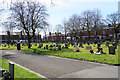
Swinton Cemetery
The newer end of the cemetery, overlooked by established housing.
Image: © Bill Boaden
Taken: 5 Apr 2018
0.24 miles