IMAGES TAKEN NEAR TO
Hillside Drive, MANCHESTER, M27 8XH
Introduction
This page details the photographs taken nearby to Hillside Drive, M27 8XH by members of the Geograph project.
The Geograph project started in 2005 with the aim of publishing, organising and preserving representative images for every square kilometre of Great Britain, Ireland and the Isle of Man.

There are currently over 7.5m images from over14,400 individuals and you can help contribute to the project by visiting https://www.geograph.org.uk
Image Map
Images are licensed for reuse under creativecommons.org/licenses/by-sa/2.0
Notes
- Clicking on the map will re-center to the selected point.
- The higher the marker number, the further away the image location is from the centre of the postcode.
Image Listing (33 Images Found)
Images are licensed for reuse under creativecommons.org/licenses/by-sa/2.0
Image
Details
Distance
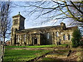
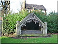
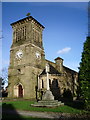
2
St John's Church, Pendlebury, Graveyard
Image: © Alexander P Kapp
Taken: 5 Feb 2008
0.07 miles
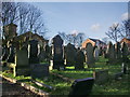
4
St John's Church, Pendlebury, Grave
Image: © Alexander P Kapp
Taken: 5 Feb 2008
0.07 miles
5
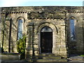
St John's Church, Pendlebury, Porch
Image: © Alexander P Kapp
Taken: 5 Feb 2008
0.07 miles
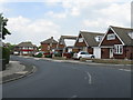
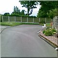
7
Broomhall Road, Pendlebury
Seen at the end of a one-way section to prevent the road becoming a cut through.
Image: © Bill Boaden
Taken: 18 Sep 2012
0.08 miles
8
St John's Church, Pendlebury, Tower
Image: © Alexander P Kapp
Taken: 5 Feb 2008
0.08 miles
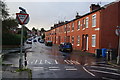
9
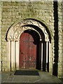
St John's Church, Pendlebury, Doorway
Image: © Alexander P Kapp
Taken: 5 Feb 2008
0.08 miles