IMAGES TAKEN NEAR TO
Vine Avenue, MANCHESTER, M27 8UU
Introduction
This page details the photographs taken nearby to Vine Avenue, M27 8UU by members of the Geograph project.
The Geograph project started in 2005 with the aim of publishing, organising and preserving representative images for every square kilometre of Great Britain, Ireland and the Isle of Man.

There are currently over 7.5m images from over14,400 individuals and you can help contribute to the project by visiting https://www.geograph.org.uk
Image Map
Images are licensed for reuse under creativecommons.org/licenses/by-sa/2.0
Notes
- Clicking on the map will re-center to the selected point.
- The higher the marker number, the further away the image location is from the centre of the postcode.
Image Listing (16 Images Found)
Images are licensed for reuse under creativecommons.org/licenses/by-sa/2.0
Image
Details
Distance
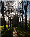
1
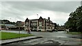
Old Station House
A building close to the former Pendlebury railway station, which was in a deep cutting to the left of this view. Old OS maps do not name this building or indicate a function such as its current use as a hotel.
Image: © Kevin Waterhouse
Taken: 12 Jul 2023
0.04 miles
3

St Augustine's School and Church
An Anglican establishment, though you might be tempted from here to think it looks Catholic. The church is a Victorian Grade I listed building.
Image: © Bill Boaden
Taken: 18 Sep 2012
0.08 miles
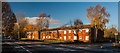
4
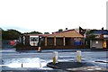
Pendlebury Evangelical Church
Seen across Bolton Road.
Image: © Bill Boaden
Taken: 18 Sep 2012
0.09 miles
5
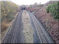
Pendlebury railway station (site), Greater Manchester
Opened in 1887 by the Lancashire & Yorkshire Railway on its line from Manchester to Wigan, this station closed in 1960. View west towards Wigan Wallgate. The main building was just above and to the left of the tunnels.
Image: © Nigel Thompson
Taken: 17 Nov 2012
0.10 miles
6
St Augustine's
St Augustine's Church at Pendlebury.
Image: © Peter McDermott
Taken: 22 Nov 2014
0.11 miles
7
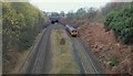
Manchester-bound train passes through Pendlebury
The central partition between the tracks was an island platform at the now closed Pendlebury railway station. The train was a late morning service to Manchester Victoria, and had just emerged from the Bolton Road tunnel in the background.
Image: © Bradley Michael
Taken: 23 Nov 2015
0.13 miles
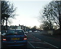
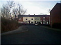
8
Pendlebury
Houses on the A666, Bolton Road.
Image: © Peter McDermott
Taken: 22 Nov 2014
0.14 miles
10
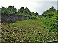
Railway Bridge on Cliveley Road
Some strimming on the left of this view allows sight of the railway towards Salford but alas to the right the flora prevents a view of the former Pendlebury Station site. Cliveley Road is no more than a very narrow path without constant clearance.
Image: © Kevin Waterhouse
Taken: 12 Jul 2023
0.19 miles